Near Valdez in Chugach Census Area, Alaska — Northwest (North America)
Goat Trail
Photographed by Barry Swackhamer, June 24, 2010
1. Goat Trail Marker
Inscription.
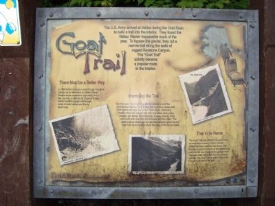
Goat Trail. . The U.S. Army arrived at Valdez during the Gold Rush to build a trail into the interior. They found the Valdez Glacier impassable much of the year. To bypass the glacier, they cut a narrow trail along the walls of rugged Keystone Canyon. The Goat Trail quickly became a popular route to the interior.,
There Must be a Better Way. In 1898 the Army found a route though Keystone Canyon as an alternative to Valdez Glacier. Despite dense vegetation, high walls, and a fast, icy river, a crew led by Corporal Robert Heiden hacked a rough trail through snarls of alder bushes and thorny devils club.,
Improving the Trail. The next year, Congress appropriated money to build the Trans-Alaska Military Road linking Fort Liscum at Valdez with Fort Egbert at Eagle City on the Yukon River. Improving Heidens four mile canyon trail with only saws, axes, picks, shovels, and sledge hammers took 35 days. Axmen hung onto brush with one hand and chopped with the other. The section above where you are standing became known as the Goat Trail for its location along the edge of the canyon walls.,
True to its Name. The Goat Trail was difficult, but safer in the summer than crossing Valdez Glacier: Winter travelers preferred the frozen river through Keystone Canyon or the glacier route until the trail was improved to a wagon road. Replace after World War II, by the present highway, the Goat Trail is now a hiking trail. It begins 200 feet to the left.
The U.S. Army arrived at Valdez during the Gold Rush to build a trail into the interior. They found the Valdez Glacier impassable much of the year. To bypass the glacier, they cut a narrow trail along the walls of rugged Keystone Canyon. The Goat Trail quickly became a popular route to the interior.
There Must be a Better Way
In 1898 the Army found a route though Keystone Canyon as an alternative to Valdez Glacier. Despite dense vegetation, high walls, and a fast, icy river, a crew led by Corporal Robert Heiden hacked a rough trail through snarls of alder bushes and thorny devils club.
Improving the Trail
The next year, Congress appropriated money to build the Trans-Alaska Military Road linking Fort Liscum at Valdez with Fort Egbert at Eagle City on the Yukon River. Improving Heidens four mile canyon trail with only saws, axes, picks, shovels, and sledge hammers took 35 days. Axmen hung onto brush with one hand and chopped with the other. The section above where you are standing became known as the Goat Trail for its location along the edge of the canyon walls.
True to its Name
The Goat Trail was difficult,
Click or scan to see this page online
but safer in the summer than crossing Valdez Glacier: Winter travelers preferred the frozen river through Keystone Canyon or the glacier route until the trail was improved to a wagon road. Replace after World War II, by the present highway, the Goat Trail is now a hiking trail. It begins 200 feet to the left.
Erected by Alaska Gold Rush Centennial.
Topics. This historical marker is listed in these topic lists: Military • Roads & Vehicles. A significant historical year for this entry is 1898.
Location. 61° 4.197′ N, 145° 53.904′ W. Marker is near Valdez in Chugach Census Area, Alaska. It is on Richardson Highway (Alaska Route 4 at milepost 13.9). The Richardson Highway mile posts were established before the 1964 Good Friday earthquake destroyed the town of Valdez. 'Old' Valdez was abandoned and 'New' Valdez was established four miles further down the road, thus the mile post for 'New' Valdez is -4 miles. Touch for map. Marker is in this post office area: Valdez AK 99686, United States of America. Touch for directions.

Regionally, this marker is in Southcentral Alaska. It is also on the American Pacific Coast. Globally, it
Photographed by Barry Swackhamer, June 24, 2010
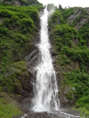
2. Horsetail Falls
is in North America, on the Ring of Fire, in the Pacific Rim, in the Western Hemisphere, in the Western World, and in the Anglosphere. Historically, it finds itself in what was once the Russian Empire.
Credits. This page was last revised on February 16, 2026. It was originally submitted on November 18, 2011, by Barry Swackhamer of Brentwood, California. This page has been viewed 968 times since then and 25 times this year. Photos:1, 2. submitted on November 18, 2011, by Barry Swackhamer of Brentwood, California. • Syd Whittle was the editor who published this page.
Editor’s want-list for this marker. Wide area view of the marker and its surroundings. •
Additional views of and from the trail. • Can you help?
