Buena Park in Orange County, California — The American West (Pacific Coastal)
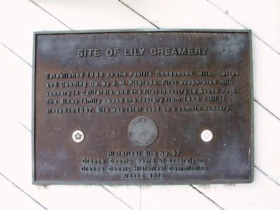
Site of Lily Creamery
Erected 1976 by Orange County Board of Supervisors and Orange County Historical Commission. (Marker Number 7.)
Topics. This historical marker is listed in this topic list: Industry & Commerce. A significant historical year for this entry is 1889.
Location. 33° 51.902′ N, 117° 59.867′ W. Marker is in Buena Park, California, in Orange County. Marker is on Beach Boulevard south of Santa Ana Freeway, on the right when traveling north. Touch for map. Marker is at or near this postal address: 6586 Beach Boulevard, Buena Park CA 90621, United States of America. Touch for directions.
Other nearby markers. At least 8 other markers are within 2 miles of this marker, measured as the crow flies. Buena Park Woman's Clubhouse (about 800 feet away, measured in a direct line); Knott's Classic Carousel (approx. 1.4 miles away); Knotts Berry Farm (approx. 1.4 miles away); Old Betsy (approx. 1˝ miles away); Blacksmith Shop (approx. 1˝ miles away); Rivera School (approx. 1˝ miles away); Birdcage Theatre (approx. 1˝ miles away); School House (approx. 1˝ miles away). Touch for a list and map of all markers in Buena Park.

Photographed By Michael Kindig, June 22, 2008
3. Fullerton Municipal Airport Marker
One mile east of the Lily Creamery Marker is the Fullerton Airport. This marker is mounted on the wall inside the terminal.
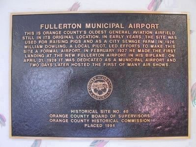
This is Orange County's oldest general aviation airfield still in its orginal location. In early years, the site was used for raising pigs and as a city sewage farm. In 1926 William Dowling, a local pilot, led efforts to make this site a formal airport. In February 1927 he made the first landing at the new Fullerton Airport in his biplane. On April 21, 1928 it was dedicated as a municpal airport and two days later hosted the first of many air shows.
Marker is located at 4011 Commonwealth Avenue, Fullerton, CA.
Credits. This page was last revised on June 16, 2016. It was originally submitted on November 29, 2011, by Michael Kindig of Elk Grove, California. This page has been viewed 1,204 times since then and 41 times this year. Photos: 1. submitted on November 29, 2011, by Michael Kindig of Elk Grove, California. 2, 3. submitted on November 30, 2011, by Michael Kindig of Elk Grove, California. • Syd Whittle was the editor who published this page.

