Orangeburg in Orangeburg County, South Carolina — The American South (South Atlantic)
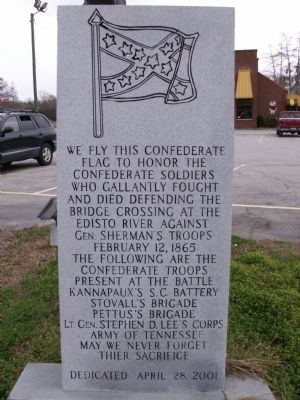
Confederate Flag
Erected 2001 by Rivers Bridge Sons of Confederate Veterans, Camp #842.
Topics. This historical marker is listed in this topic list: War, US Civil. A significant historical date for this entry is February 12, 1935.
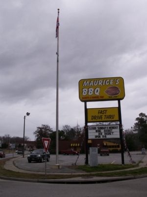
Location. 33° 29.016′ N, 80° 52.317′ W. Marker is in Orangeburg, South Carolina, in Orangeburg County. Marker is at the intersection of John C. Calhoun Drive (U.S. 301) and Russell Street (State Route 33), in the median on John C. Calhoun Drive. Touch for map. Marker is at or near this postal address: 1586 John C Calhoun Drive, Orangeburg SC 29115, United States of America. Touch for directions.
Other nearby markers. At least 8 other markers are within walking distance of this marker. Veterans Memorial Park (about 700 feet away, measured in a direct line); Veterans Memorial Fountain (about 700 feet away); Orangeburg County / Discovering Orangeburg (approx. 0.2 miles away); Defense of Edisto Bridge (approx. half a mile away); Albergotti Playground (approx. half a mile away); Jewish Merchants/Jewish Life (approx. 0.6 miles away); Pioneer Graveyard (approx. 0.6 miles away); The Two Old Guns Of Captain Henry Felder (approx. 0.7 miles away). Touch for a list and map of all markers in Orangeburg.
Also see . . . The Times & Democrat article: "Orangeburg says it can’t force down Confederate flag". The nearby restaurant wants the Confederate battle flag, which is right next to this marker, removed but does not own the .003-acre parcel it is located on. The city says they currently cannot do anything to remove it. (Submitted on June 24, 2017.)
Credits. This page was last revised on June 12, 2021. It was originally submitted on February 5, 2012, by Anna Inbody of Columbia, South Carolina. This page has been viewed 1,006 times since then and 36 times this year. Photos: 1, 2. submitted on February 5, 2012, by Anna Inbody of Columbia, South Carolina. • Craig Swain was the editor who published this page.

