Shannon Township near Atchison in Atchison County, Kansas — The American Midwest (Upper Plains)
"this day being…the 4th of July"
Photographed by William Fischer, Jr., December 9, 2011
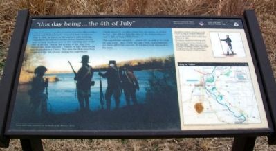
1. "this day being...the 4th of July" Marker
The U.S. Army expedition led by Captains Meriwether Lewis and William Clark camped in this vicinity on July 4, 1804. In honor of the nation's 28th birthday, expedition members fired the swivel cannon on the bow of their keelboat once in the morning and at the end of the day. During the course of the day, they named two local streams - Fourth of July 1804 Creek and Independence Creek. This was the first time they celebrated the 4th of July during the expedition.
Clark wrote: "...as this Creek has no name, and this being...the 4th of July the day of the independance...call it 4th of July 1804 Creek..."
The expedition camped "...above the mouth of a Creek 20 yds wide this Creek we call Creek Independence..." An extra gill [four ounces] of whiskey was rationed to the men.
Expedition members turned out on the Fourth of July in striking regimental coats. Artist Michael Haynes depicts Captain Meriwether Lewis in full dress uniform at right.
During the expedition's journey west, impromptu ceremonies marked three holidays: Fourth of July, Christmas, and New Year's. Other occasions, such as Lewis' birthday, a notable discovery,
this page online
[Background photo caption reads]
Lewis and Clark reenactors on the banks of the Missouri River.
Erected by Kansas Lewis and Clark Bicentennial Commission; National Park Service, U.S. Department of the Interior.
Topics and series. This historical marker is listed in these topic lists: Exploration • Waterways & Vessels. In addition, it is included in the Lewis & Clark Expedition series list. A significant historical month for this entry is July 1673.
Location. 39° 37.276′ N, 95° 5.874′ W. Marker is near Atchison, Kansas, in Atchison County. It is in Shannon Township. It can be reached from Orphans Home Road. Marker is at the north end of the bridge over Independence Creek at Independence Creek Lewis & Clark Historic Site. Touch for map. Marker is at or near this postal address: 19920 Orphans Home Rd, Atchison KS 66002, United States of America. Touch for directions.

Regionally, this marker is in Eastern Kansas. It is also in the American Midwest, in the Lewis & Clark Corridor, in the Corn Belt, on the prairies, and on the Southern Plains. Globally, it is
Photographed by William Fischer, Jr., December 9, 2011
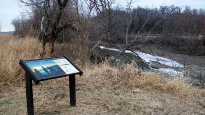
2. "this day being...the 4th of July" Marker and Independence Creek
Other nearby markers. At least 8 other markers are within 4 miles of this marker, measured as the crow flies: "Grand Village des Canzes" (about 300 feet away, measured in a direct line); Samuel T. Carpenter (approx. 2.3 miles away); B. P. Waggener House (approx. 3.7 miles away); Lincoln School (approx. 3.7 miles away); Webster Wirt Hetherington House (approx. 3.7 miles away); Muchnic House (approx. 3.8 miles away); Lincoln Address (approx. 4 miles away); Atchison County Courthouse (approx. 4 miles away). Touch for a list and map of all markers in Atchison.
Also see . . .
1. Lewis and Clark National Historic Trail. (Submitted on February 26, 2012, by William Fischer, Jr. of Reynoldsburg, Ohio.)
2. The Journals of the Lewis and Clark Expedition. (Submitted on February 26, 2012, by William Fischer, Jr. of Reynoldsburg, Ohio.)
Photographed by William Fischer, Jr., December 9, 2011
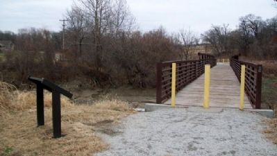
3. "this day being...the 4th of July" Marker
Looking SW across bridge over Independence Creek
Photographed by National Park Service, undated
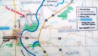
4. Map on "this day being...the 4th of July" Marker
Credits. This page was last revised on September 1, 2020. It was originally submitted on February 26, 2012, by William Fischer, Jr. of Reynoldsburg, Ohio. This page has been viewed 1,411 times since then and 39 times this year. Photos: 1, 2, 3, 4. submitted on February 26, 2012, by William Fischer, Jr. of Reynoldsburg, Ohio.
