Near Chinese Camp in Tuolumne County, California — The American West (Pacific Coastal)
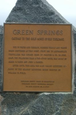
Green Springs
Gateway to the Gold Mines of Old Tuolumne
After 1870, this area was also called Keystone because of the nearby Keystone House erected by William H. Field.
Erected 1980 by Tuolumne Board of Supervisors and Tuolumne County Historical Society. (Marker Number 6.)
Topics. This historical marker is listed in these topic lists: Roads & Vehicles • Settlements & Settlers. A significant historical month for this entry is June 1849.
Location. 37° 50.255′ N, 120° 30.44′ W. Marker is near Chinese Camp, California, in Tuolumne County. Marker is at the intersection of Green Springs Road and La Grange Road, on the left when traveling south on Green Springs Road. Touch for map. Marker is in this post office area: Chinese Camp CA 95309, United States of America. Touch for directions.
Other nearby markers. At least 8 other markers are within 8 miles of this marker, measured as the crow flies. Old Crimea House (approx. 1.6 miles away); To Honor Eddie Webb (approx. 4.7 miles away); Chinese Camp (approx. 4.7 miles away); O'Byrne Ferry (approx. 5.6 miles away); Montezuma (approx. 5.8 miles away); Jacksonville (approx. 6.9 miles away); Don Pedro Lake (approx. 6.9 miles away); Willms Ranch (approx. 8 miles away). Touch for a list and map of all markers in Chinese Camp.
Credits. This page was last revised on June 16, 2016. It was originally submitted on March 7, 2012, by Barry Swackhamer of Brentwood, California. This page has been viewed 806 times since then and 33 times this year. Photos: 1, 2. submitted on March 7, 2012, by Barry Swackhamer of Brentwood, California. • Syd Whittle was the editor who published this page.

