Rice in Amelia County, Virginia — The American South (Mid-Atlantic)
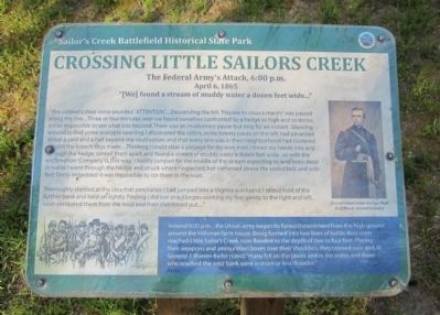
Crossing Little Sailor's Creek
The Federal Army's Attack, 6:00 p.m. April 6, 1865
| — | Sailor's Creek Battlefield Historical State Park | — |
Photographed by Bernard Fisher, April 12, 2012
1. Crossing Little Sailor's Creek Marker
"We found a stream of muddy water a dozen feet wide..."
“The colonel’s clear voice sounded ‘ATTENTION’....Descending the hill; ‘Prepare to cross a marsh!’ was passed along the line....Three or four minutes later we found ourselves confronted by a hedge so high and so dense, it was impossible to see what was beyond. There was an involuntary pause-but only for an instant. Glancing around to find some available opening, I discovered the colors, some twenty paces on the left, had advanced about a yard and a half beyond the obstruction, and that every one was in their neighborhood had clustered around the breach thus made....Thinking I could clear a passage for my own men, I thrust my hands into and through the hedge, spread them apart and found a stream of muddy water a dozen feet wide…so with the exclamation ‘Company G, this way,’ I boldly jumped for the middle of the stream expecting to land knee-deep in water. I went through the hedge and struck where I expected, but immersed above the sword belt, and with feet firmly imbedded it was impossible to stir them in the least.
Thoroughly startled at the idea that perchance
this page online
(sidebar)
Around 6:00 pm…the Union army began its forward movement from the high ground around the Hillsman farm house. Being formed into two lines of battle, they soon reached Little Sailor’s Creek, now flooded to the depth of two to four feet. Placing their weapons and ammunition boxes over their shoulders, they crossed over and, as General J. Warren Keifer noted “many fell on the plains and in the water, and those who reached the west bank were in more or less disorder.”
Erected by Sailor's Creek Battlefield Historical State Park.
Topics. This historical marker is listed in this topic list: War, US Civil.
Location. Marker has been reported permanently removed. It was located near 37° 18.396′ N, 78° 13.565′ W. Marker was in Rice, Virginia, in Amelia County. It could be reached from Saylers Creek Road (Virginia Route 617) 0.6 miles north of
Photographed by Bernard Fisher, April 12, 2012
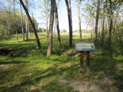
2. Crossing Little Sailor's Creek Marker
We have been informed that this marker is no longer there and will not be replaced. This page is an archival view of what was.
Regionally, this marker was in the Piedmont and in Central Virginia. It was also in the American South and specifically in the Upper South. Globally, it was in North America, the Western Hemisphere, the Western World, and the Anglosphere. Historically, it found itself in what was once the territory of the Mississippian Culture, one of the original Thirteen Colonies, one of the Confederate States of America, and the Antebellum South.

Other nearby markers. At least 8 other markers are within 2 miles of this location, measured as the crow flies: General Wheaton's First Division Assault (about 400 feet away, measured in a direct line); Rock Formations At Sailor's Creek (approx. ¼ mile away); The Federal Artillery Barrage (approx. 0.3 miles away); Battle of Sailor's (Sayler's) Creek
Photographed by Bernard Fisher, April 12, 2012
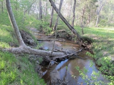
3. Sailor's Creek
Other markers no longer nearby. Assaulting the Confederate Battle Line (was about 700 feet away but has been permanently removed); The Final Clash: With Fate Against Them (was approx. 0.2 miles away but has been permanently removed); Ewell’s Line of Defense (was approx. ¼ mile away but has been permanently removed); Victory or Death (was approx. 0.3 miles away but has been permanently removed); Overton/Hillsman House (was approx. 0.3 miles away but has been replaced with another marker now near it); Hillsman House (was approx. 0.4 miles away but has been permanently removed); Holt’s Corner (was approx. 1.2 miles away but has been permanently removed).
Also see . . . Sailor's Creek Battlefield Historical State Park. Virginia Department of Conservation & Recreation (Submitted on April 15, 2012, by Bernard Fisher of Richmond, Virginia.)
Credits. This page was last revised on February 8, 2026. It was originally submitted on April 15, 2012, by Bernard Fisher of Richmond, Virginia. This page has been viewed 1,577 times since then and 62 times this year. Last updated on February 7, 2026, by Evan Dwyer of Richmond, Virginia. Photos: 1, 2, 3. submitted on April 15, 2012, by Bernard Fisher of Richmond, Virginia.
