Thomaston in Knox County, Maine — The American Northeast (New England)
Near the Old Prison
⎯⎯⎯
À Coté de l'Ancienne Prison
Thomaston, Maine
| — | The Museum in the Streets | — |
Photographed by William Fischer, Jr., September 20, 2011
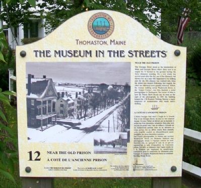
1. Near the Old Prison / À Coté de l'Ancienne Prison Marker

Near the Old Prison
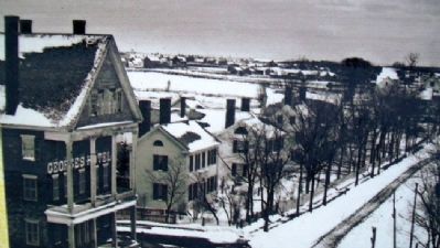
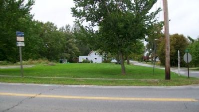
The Georges Hotel stood at the intersection of Main and Georges Street where there now is an empty lot. It burned to the ground leaving the three chimneys standing. On a very windy day several years after the fire, one of the chimneys was blown over on a man who happened to be walking past the site. His absence was realized only when the debris was cleared. Following that tragedy, the other two chimneys were quickly removed. Below, the woman walking across Wadsworth Street, at the "Upper Corner", was Mrs. Sanford, a noted photographer in Thomaston. The corner of what is now the Prison Show Room can be seen on the right of the photograph. In 1892 the building housed the J. B. Pearson Clothing Factory, a major employer of seamstresses who made men's clothing.
L'Hôtel Georges était situé à l'angle de la Grande Rue et de Georges Street, où rien n'a été construit depuis. Un jour, l'hôtel est détruit par un incendie et seules ses trois cheminées subsistent. Bien plus tard, un jour de grand vent, l'une de celles-ci s'écroule sur un malheureux passant dont on ne décourvre
this page online
Erected by The Museum in the Streets®. (Marker Number 12.)
Topics. This historical marker is listed in these topic lists: Arts, Letters, Music • Industry & Commerce • Women. A significant historical year for this entry is 1892.
Location. 44° 4.667′ N, 69° 11.438′ W. Marker is in Thomaston, Maine, in Knox County. It is at the intersection of City Avenue / Main Street (Maine Route 131) and Georges Street, on the right when traveling east on City Avenue / Main Street. Touch for map. Marker is in this post office area: Thomaston ME 04861, United
Photographed by Unknown, undated
2. Main Photo on Near the Old Prison / À Coté de l'Ancienne Prison Marker

Regionally, this marker is in Midcoast Maine and on Penobscot Bay. It is also in the American Northeast, in New England, and on the Eastern Seaboard. Globally, it is in the North Atlantic Region, North America, the Western Hemisphere, the Western World, and the Anglosphere.
Other nearby markers. At least 8 other markers are within walking distance of this marker: A Unique Pumper and Old Fire Houses (within shouting distance of this marker); Maine State Prison (about 500 feet away, measured in a direct line); Former State Prison Site (about 500 feet away); Maine State Prison at Thomaston (about 600 feet away); 178 Years of History / 178 Ans d'Histoire (about 700 feet away); War Memorial (about 800 feet away); The Voyage of Captain George Waymouth (approx. 0.2 miles away); Days of Old (approx. 0.2 miles away). Touch for a list and map of all markers in Thomaston.
Also see . . . Thomastown Historical Society. Website homepage (Submitted on December 23, 2025, by Larry Gertner of New York, New York.)
Photographed by William Fischer, Jr., September 20, 2011
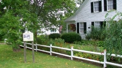
3. Near the Old Prison / À Coté de l'Ancienne Prison Marker
Photographed by William Fischer, Jr., September 20, 2011
4. Empty Lot Where Georges Hotel Once Stood
Credits. This page was last revised on December 23, 2025. It was originally submitted on April 20, 2012, by William Fischer, Jr. of Reynoldsburg, Ohio. This page has been viewed 916 times since then and 20 times this year. Photos: 1, 2, 3, 4. submitted on April 20, 2012, by William Fischer, Jr. of Reynoldsburg, Ohio.
