Near Arlington in Maricopa County, Arizona — The American Mountains (Southwest)
Historic Gillespie Dam Bridge
Photographed by Wyndfire, April 28, 2012
1. Historic Gillespie Dam Bridge Marker
Main Marker, Side A
Main Marker - Side A:
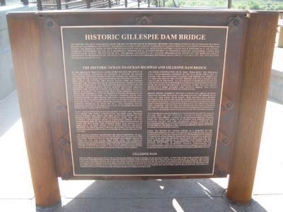
The Historic Gillespie Dam Bridge spans the Gila River on Old US 80 Highway, between the communities of Arlington and Gila Bend. Built in 1927 as a Federal Aid Project, the bridge is a unique and elegant reminder of Arizona's rich past and America's transportation history. The bridge is listed on both the Arizona State and National Register of Historic Places and is referred to in the Historic American Engineering Record as a significant technological accomplishment in Twentieth Century engineering design and construction. During the Winter of 2011, the bridge underwent a $7.3 million rehabilitation effort by the Maricopa County Department of Transportation. This project was designated a 2012 Arizona Centennial Legacy Project and included the construction of this interpretive plaza.
this page online
In 1921, the highway route was realigned to ford the Gila River just below the newly constructed Gillespie Dam. Heading south toward Gila Bend, the new route was known as the Phoenix-Yuma Highway. The following year, the Arizona Highway Department built a concrete apron on the downstream side of the Gillespie Dam to help automobiles to cross the Gila River. This crossing point also provide to be unreliable, as high water often made passage difficult. Between 1922 and 1926, large trucks, tractors and horse teams were frequently used to pull automobiles across
Photographed by Wyndfire, April 28, 2012
2. Historic Gillespie Dam Bridge Marker - Side B
The Arizona Highway Department set about designing an all-weather bridged structure in 1925 to span the Gila River at this location. Construction of the Gillespie Dam Bridge began in February 1926 and later that same year, the American Association of State Highway Officials adopted our present day highway numbering system. When the new Gillespie Dam Bridge opened to traffic on August 1, 1927, it was officially designated part of the early southern continental US 80 Highway.
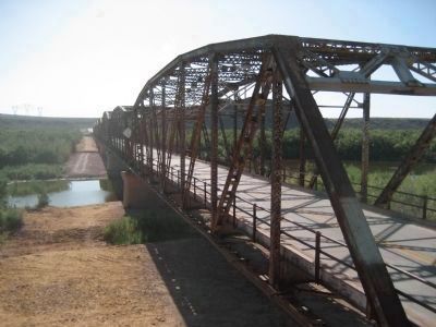
Lee Moor Construction of El Paso, Texas built the nine-span steel truss bridged crossing of the Gila River for a cost of $320,000. The 1,662-foot-long Gillespie Dam Bridge was unique for its time and one of the longest bridges and the largest steel structure in the state. All of Arizona's major bridges before this were built using reinforced concrete arches which proved to be no match for swollen, flooding rivers. The new design produced a more durable and flexible bridge that could better withstand the force of flood waters.
Bridge design elements include a connected series of rigid through trusses weighing 2.3 million pounds. The bridge has a total of nine steel truss spans - five 200-foot-long trusses centered over the river channel,
Photographed by Wyndfire, April 28, 2012
3. Historic Gillespie Dam Bridge Marker - Side C
The new bridge and US 80 Highway through the Arlington Valley became part of the National "Ocean-to-Ocean Highway". Gillespie Dam Bridge carried US 80 transcontinental traffic from 1927 to 1956, when US 80 Highway was shifted east to Rainbow Valley and the Arlington Valley stretch was decommissioned as an interstate route. The operation, care and ownership of the bridge were then transferred from the State of Arizona to Maricopa County.
While the Bridge no longer serves as a segment of the interstate highway system, it is continually used by locals and is enjoyed by travelers who bypass the newer highway to take in a glimpse of an era gone by. Today, historic Gillespie Dam Bridge on Old US 80, nestled between the Buckeye Hills and the Gila Bend Mountains, serves as an integral plan element in the Arizona Department of Transportation's statewide bicycle system plan, the Maricopa County Department
Photographed by Wyndfire, April 28, 2012
4. Historic Gillespie Dam Bridge Interpretive Plaza
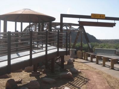
Marker rotunda to the left, bridge entrance to the right.
Side B:
Photographed by Wyndfire, April 28, 2012
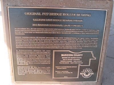
5. Original 1927 Bridge Roller Bearing
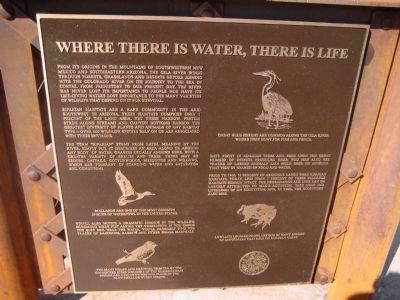
Riparian habitats are a rare commodity in the arid Southwest. in Arizona, these habitats comprise only 1 percent of the land area, yet these narrow, fertile strips along streams and canyon bottoms harbor the greatest diversity of plants and animals of any habitat type - over 600 wildlife species rely on or are associated with these environs.
The term "riparian" stems from Latin, meaning by the river, simply put, it describes an area along or around any body of water. Grasses usually abound here, with a greater variety of shrubs and trees. There may be sedges, cattails, cottonwoods, mesquites and willows, which are tolerant of standing water and saturated soil conditions.
Mallards are one of the most common species of waterfowl in the United States.
You'll also notice a dramatic change in the wildlife. Numerous birds flit among the vegetation. If you check the soft soil near the water, you'll probably find the tracks of raccoons, rabbits and other small mammals.
The many nooks and crannies created by the connected steel members of the Gillespie Dam Bridge are a favorite nesting place of the Cliff Swallow every spring.
Great Blue
Photographed by Wyndfire, April 28, 2012
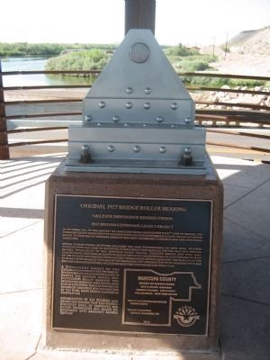
6. Original 1927 Bridge Roller Bearing
Original 1927 Bridge Roller Bearing - marker and bearing
Bats roost in riparian trees and feed upon the great number of insects produced here. You may also see tracks of larger animals like mule deer or javelina that visit in search of food and water.
Prior to 1900, 10 percent of Arizona's lands were riparian habitats. Today, less than 1 percent of these valuable habitats remain intact. The degradation and loss can be largely attributed to man's activities. Take away the lifeblood of an ecosystem, and, in time, the ecosystem also dies.
Lowland Leopard Frogs are one of many species of amphibians that rely on riparian areas.
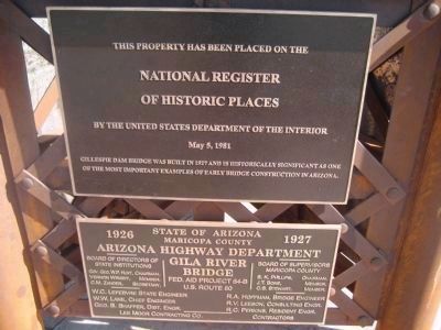
Main Marker - Side C:
Upper Plaque
National Register
of Historic Places
by the United States Department of the Interior
May 5, 1981
Lower Plaque:
Gila River Bridge
Fed. Aid Project 64-B
U.S. Route 80
Arizona Highway Department
Board of Directors of State Institutions
Gov. Geo. W.P. Hunt, Chairman • Vernon Wright, Member • C.M. Zander, Secretary
Photographed by Wyndfire, April 28, 2012
7. Historic Gillespie Dam Bridge
Gillespie Dam Bridge, heading westbound
Board of Supervisors
Maricopa County
S.K. Phillips, Chairman • J.T. Bone, Member • C.S. Stewart, Member • R.A. Hoffman, Bridge Engineer • R.V. Leeson, Consulting Engr. • R.C. Perkins, Resident Engr.
Lee Moor Contracting Co. Contractors
Second Marker:
Gillespie Dam Bridge Rehabilitation
2012 Arizona Centennial Legacy Project
Bridge rehabilitation activities included the heat straightening of bent steel members damaged over the years by automobiles and large farm vehicles; pipe rail and sway bracing repairs; installation of new approach guard railing; concrete repairs and wing wall modifications; and reinforcement of bridge piers in accordance with United States Department of the Interior and Arizona State Historic Preservation Office guidelines. The repaving of the roadway approaches at each end of the bridge
Photographed by Wyndfire, April 28, 2012
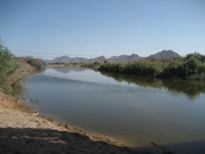
8. Gila River, south of the Gillespie Dam Bridge
A significant aspect of the rehabilitation project was the span-by-span hydraulic jacking of the bridge to remove the original rused non-functioning roller bearings. New modern pad bearings were installed as part of this effort, which allow for the necessary expansion and contraction of the steel spans during changes in temperature.
Rehabilitation of the Gillespie Dam Bridge has ensured that this historic structure shall be conserved for future generations and allow its enjoyment into Arizona's second century.
Maricopa County
Board of Supervisors
Max W. Wilson, Chairman • Andrew Kunasek • Don Stapley • Fulton Brock • Mary Rose Wilcox
County Administrative Officer
David R. Smiith
County Engineer
John B. Hauskins, R.E.
Arizona Centennial 1912 - 2012
Erected 2012 by Maricopa County Board of Supervisors.
Topics. This historical marker is listed in these topic lists: Bridges & Viaducts • Waterways & Vessels. A significant historical month for this entry is February 1926.
Location. 33° 13.703′ N, 112° 45.998′ W. Marker is near Arlington, Arizona, in Maricopa County. It is on Old US 80 Highway (U.S. 80),
Photographed by Wyndfire, April 28, 2012
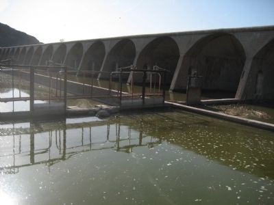
9. Gillespie Dam
A section of the dam and old irrigation controls.

Regionally, this marker is in the Sonoran Desert, in the Phoenix Metropolitan Area, and in the Tohono O’odham Nation. It is also in the American Southwest. Globally, it is in North America, the Western Hemisphere, the Western World, and the Anglosphere. Historically, it finds itself in what was once New Spain, the Gadsden Purchase, and Mexico’s Alta California.
Other nearby markers. At least one other marker is within walking distance of this marker: Original 1927 Bridge Roller Bearing (about 300 feet away, measured in a direct line).
More about this marker. There is a small rotunda on the left side of the highway, on the east bank of the river, with the historical markers. One marker is tri-sided.
Also see . . . Most Endagered Bridge. Details of the condition of the bridge prior to the renovation. (Submitted on May 3, 2012.)
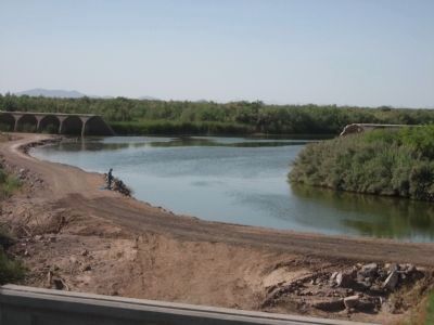
Photographed by Wyndfire, April 28, 2012
10. Gillespie Dam, north of the bridge.
Shows the breach in the dam, allowing the Gila River to flow through. Dam was breached in 1993 and never repaired.
Credits. This page was last revised on June 16, 2016. It was originally submitted on April 29, 2012, by Jennifer W. of Las Cruces, New Mexico. This page has been viewed 5,153 times since then and 89 times this year. Photos: 1, 2, 3, 4, 5, 6, 7, 8, 9, 10. submitted on April 29, 2012, by Jennifer W. of Las Cruces, New Mexico. • Syd Whittle was the editor who published this page.
