Wells in York County, Maine — The American Northeast (New England)
Civil War Soldiers Monument

Photographed by William Fischer, Jr., September 26, 2011
1. Civil War Soldiers Monument
brave and patriotic Soldiers
of Wells who sacrificed their lives
during the Great Rebellion in
maintaining our Government and
thus establishing on a broader and
firmer foundation the principle of
civil and religious liberty
[Honor Roll]
James A. Bedell • Moses Perkins • Andrew J. Goodale • Daniel Rankin • Fredric Donnell • Wilson J. Green • Joseph Green • Nathaniel Eaton • Ezra Cousens • John A. Brown • Sylvester Hatch • Joseph S. Getchell • James Wilber • Lorenzo Bennet • Andrew J. Hobbs • John B. Hilton • George W. Maxwell • Lyman L. Stuart • Hermon S. Furbish • Moses Donnell • John Matthews • Elbridge Hilton • Ivory Hatch • James Richardson • Alonzo Hatch • Albert L. Gardener • William N. Hatch Jr. • Walter Eaton • Joseph E. Hatch • Daniel Bennet • William J. Bragdon • Jarious Abbot • Ebenezer Chaney
Erected by John Storer, Esqr. of Sanford and the Inhabitants of Wells.
Topics. This monument and memorial is listed in these topic lists: Patriots & Patriotism • War, US Civil.
Location. 43° 19.173′ N, 70° 34.897′ W. Monument is in Wells, Maine, in York County. It is on Post Road (U.S. 1), on the left when traveling south. Monument is in Ocean View Cemetery. Touch for map. Monument is at or near this postal address: 1485 Post Road, Wells ME 04090, United States of America. Touch for directions.

Regionally, this memorial monument is on Southern Maine Coast. It is also in the American Northeast, in New England, and on the Eastern Seaboard. Globally, it is in the North Atlantic Region, North America, the Western Hemisphere, the Western World, and the Anglosphere.
Other nearby markers. At least 8 other markers are within 2 miles of this marker, measured as the crow flies: World War Memorial (a few steps from this
this page online

Photographed by William Fischer, Jr., September 26, 2011
2. Civil War Soldiers Monument Dedication
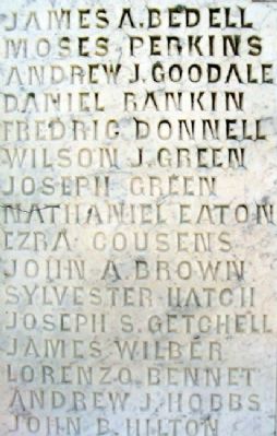
Photographed by William Fischer, Jr., September 26, 2011
3. Civil War Soldiers Monument Honor Roll

Photographed by William Fischer, Jr., September 26, 2011
4. Civil War Soldiers Monument Honor Roll

Photographed by William Fischer, Jr., September 26, 2011
5. Coxswain Charles H. Smith, US Navy
Credits. This page was last revised on November 15, 2021. It was originally submitted on May 25, 2012, by William Fischer, Jr. of Reynoldsburg, Ohio. This page has been viewed 1,133 times since then and 40 times this year. Photos: 1, 2, 3, 4, 5. submitted on May 25, 2012, by William Fischer, Jr. of Reynoldsburg, Ohio.
