Dayton in Rhea County, Tennessee — The American South (East South Central)
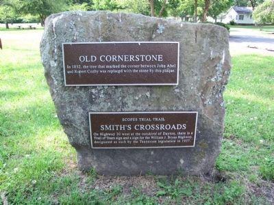
Old Cornerstone / Smith's Crossroads
Scopes Trial Trail
Old Cornerstone
In 1832, the tree that marked the corner between John Abel and Robert Cosby was replaced with the stone by this plaque.
Smith's Crossroads
On Highway 30 west at the outskirts of Dayton, there is a Trail of Tears sign and a sign for the William J. Bryan Highway, designated as such by the Tennessee legislature in 1937.
Topics. This historical marker is listed in these topic lists: Roads & Vehicles • Settlements & Settlers. A significant historical year for this entry is 1832.
Location. 35° 29.217′ N, 85° 1.191′ W. Marker is in Dayton, Tennessee, in Rhea County. Marker is at the intersection of Market Street and Florida Avenue, on the left when traveling north on Market Street. Touch for map. Marker is at or near this postal address: 798 Market Street, Dayton TN 37321, United States of America. Touch for directions.
Other nearby markers. At least 8 other markers are within walking distance of this marker. Smith’s Crossroads (within shouting distance of this marker); Site of F.R. Rogers Home (about 300 feet away, measured in a direct line); Walter F. Thomison Home (about 700 feet away); Broyles-Darwin House (about 700 feet away); First United Methodist Church (approx. 0.2 miles away); F.E. Robinson's Drug Store, Aqua Hotel, Cumberland Presbyterian Church (approx. half a mile away); Bailey Hardware (approx. 0.6 miles away); John Morgan Furniture (approx. 0.6 miles away). Touch for a list and map of all markers in Dayton.
Related markers. Click here for a list of markers that are related to this marker.
Credits. This page was last revised on June 16, 2016. It was originally submitted on May 29, 2012, by Lee Hattabaugh of Capshaw, Alabama. This page has been viewed 752 times since then and 16 times this year. Photos: 1, 2, 3. submitted on May 29, 2012, by Lee Hattabaugh of Capshaw, Alabama. • Bernard Fisher was the editor who published this page.


