Near Fredericksburg in Spotsylvania County, Virginia — The American South (Mid-Atlantic)
For All Anguish – For Some Freedom
Fredericksburg and Spotsylvania National Military Park
— National Park Service, U.S. Department of the Interior —
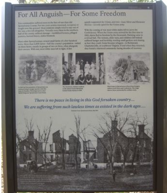
Few communities suffered more in the face of war than did Spotsylvania County. For two years armies traversed, occupied, or fought over this ground. Most residents simply tried to stay out of the way; a few left altogether. Virtually every farm in the northern half of the county suffered damage – vandalized houses, pillaged pantries, burned fences, stolen livestock.
Most white Spotsylvanians owned small farms of a few hundred acres. More than 6,000 slaves – half the county’s population – toiled on these farms, usually in groups of two or three, often alongside their owners. With war, most white men left to fight. A few quietly supported the Union, and two – Isaac Silver and Ebenezer McGee – secretly spied for the Union army.
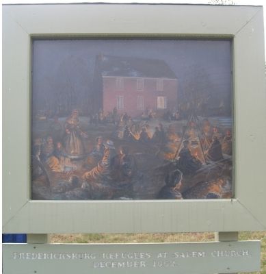
With the coming of war most white males left to serve the Confederacy. When the Union army arrived for the first time in 1862, slaves fled to freedom by the thousands. Farming came to a virtual halt. The women, older men, and children left behind suffered hunger and hardship, tending small gardens and sharing as best they could. Some became refugees – to Richmond, Charlottesville, or southwest Virginia. If and when they returned, they found a shattered community facing decades of recovery.
(Picture caption, top left): In 1860 half the population of Spotsylvania was enslaved, living in meager quarters with little hope for freedom. This image shows a slave family living near Spotsylvania Court House.
(Picture caption, top center): The Morrisons, wartime residents on the Salem Church Battlefield, hosted Union veterans in 1892.
(Picture caption, top right): Most homes in Spotsylvania suffered from foraging soldiers, both Union and Confederate. This image shows a house surrounded by a military camp.
We are suffering from such lawless times as existed in the dark ages….
Katherine Couse, Spotsylvania resident, May 1864.
(Picture caption, bottom): Though the ruins of the Chancellor house came to symbolize the plight of white Spotsylvanians, in fact few homes in the county suffered outright destruction. Most homes suffered from foraging soldiers, both Union and Confederate.
Erected by National Park Service, U.S. Department of the Interior.
Topics. This historical marker is listed in these topic lists: African Americans • Military • War, US Civil. A significant historical date for this entry is May 17, 1864.
Location. 38° 17.298′ N, 77° 31.853′ W. Marker is near Fredericksburg, Virginia, in Spotsylvania
County. Marker can be reached from Old Salem Church Road near Plank Road (Virginia Route 3). This marker is colocated with two other markers near the parking lot for the Old Salem Church (Civil War Battlefield) Site. Touch for map. Marker is at or near this postal address: 4044 Plank Road, Fredericksburg VA 22407, United States of America. Touch for directions.
Other nearby markers. At least 8 other markers are within walking distance of this marker. Sanctuaries in Spotsylvania (here, next to this marker); Churchyard to Battleground (here, next to this marker); Salem Church (within shouting distance of this marker); Old Salem Church (within shouting distance of this marker); Refuge from Horror (within shouting distance of this marker); The Battle of Salem Church (about 300 feet away, measured in a direct line); From Church to Hospital (about 300 feet away); a different marker also named Battle of Salem Church (about 300 feet away). Touch for a list and map of all markers in Fredericksburg.
Regarding For All Anguish – For Some Freedom. This is one of five stops at Salem Church related to the Battle of Chancellorsville. See the Salem Church Virtual Tour by Markers in the links section for a listing of related markers on the tour.
Also see . . .
1. Salem Church Virtual Tour by Markers. The Salem Church site, surrounded by modern development, was an important site in the later stages of the Battle and Campaign of Chancellorsville. (Submitted on November 12, 2007, by Craig Swain of Leesburg, Virginia.)
2. Salem Church Walking Trail. National Park Service trail guide. (Submitted on November 12, 2007, by Craig Swain of Leesburg, Virginia.)
Credits. This page was last revised on February 2, 2023. It was originally submitted on November 12, 2007, by Kevin W. of Stafford, Virginia. This page has been viewed 1,225 times since then and 30 times this year. Last updated on February 22, 2008, by Christopher Busta-Peck of Shaker Heights, Ohio. Photos: 1, 2, 3. submitted on November 12, 2007, by Kevin W. of Stafford, Virginia. • Craig Swain was the editor who published this page.


