El Dorado Springs in Cedar County, Missouri — The American Midwest (Upper Plains)
Prairie
A year-round palette of colors
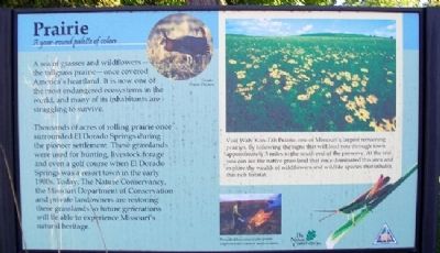
A sea of grasses and wildflowers - the tallgrass prairie - once covered America's heartland. It is now one of the most endangered ecosystems in the world, and many of its inhabitants are struggling to survive.
Thousands of acres of rolling prairie once surrounded El Dorado Springs during the pioneer settlement. These grasslands were used for hunting, livestock forage and even a golf course when El Dorado Springs was a resort town in the early 1900s. Today, The Nature Conservancy, the Missouri Department of Conservation and private landowners are restoring these grasslands so future generations will be able to experience Missouri's natural heritage.
[Main inset photo caption reads]
Visit Wah'Kon-Tah Prairie, one of Missouri's largest remaining prairies, by following the signs that will lead you through town appoximately 3 miles to the south end of the preserve. At the site, you can see the native grassland that once dominated this area and explore the wealth of wildflowers and wildlife species that inhabit this rich habitat.
Erected by The Nature Conservancy and the Missouri Department of Conservation.
Topics. This historical marker is listed in these topic lists: Environment • Settlements & Settlers.
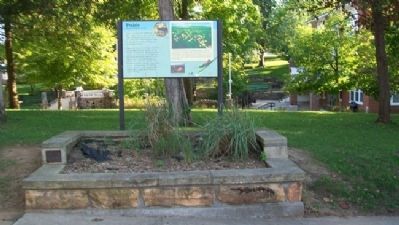
Location. 37° 52.601′ N, 94° 1.332′ W. Marker is in El Dorado Springs, Missouri, in Cedar County. Marker is on Spring Street near Main Street (Missouri Route 82), on the left when traveling west. Marker is on the north edge of City Park. Touch for map. Marker is in this post office area: El Dorado Springs MO 64744, United States of America. Touch for directions.
Other nearby markers. At least 8 other markers are within walking distance of this marker. Nathaniel H. and Waldo P. Cruce (a few steps from this marker); Roy Bandy and Eddy Wilson (within shouting distance of this marker); El Dorado Spring (within shouting distance of this marker); City Park Dedication (within shouting distance of this marker); Grindstone Wash Basin (within shouting distance of this marker); Former School Districts in El Dorado Springs R-2 (approx. 0.6 miles away); Veterans Memorial (approx. 0.6 miles away); Missouri Bicentennial Wagon (approx. 0.7 miles away). Touch for a list and map of all markers in El Dorado Springs.
Also see . . .
1. Wah'Kon-Tah Prairie, Missouri. The Nature Conservancy website entry (Submitted on July 6, 2012, by William Fischer, Jr. of Scranton, Pennsylvania.)
2. Tallgrass Prairie National Preserve. National Park Service website entry (Submitted on July 6, 2012, by William Fischer, Jr. of Scranton, Pennsylvania.)
Credits. This page was last revised on June 26, 2022. It was originally submitted on July 6, 2012, by William Fischer, Jr. of Scranton, Pennsylvania. This page has been viewed 512 times since then and 6 times this year. Photos: 1, 2. submitted on July 6, 2012, by William Fischer, Jr. of Scranton, Pennsylvania.

