Manitowoc in Manitowoc County, Wisconsin — The American Midwest (Great Lakes)
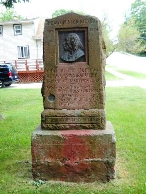
The Wampum or Mexico
1789 - 1844
Ottawa and Menominee
Indians of Manitowoc Co
Signed the treaties of
Butte des Mortes - 1827
Green Bay - 1828
Prairie du Chien - 1829
Chicago - 1833
Friend of the Early Settlers
Erected 1909 by Manitowoc County Historical Society.
Topics. This historical marker is listed in these topic lists: Cemeteries & Burial Sites • Native Americans • Settlements & Settlers. A significant historical year for this entry is 1827.
Location. 44° 5.839′ N, 87° 42.248′ W. Marker is in Manitowoc, Wisconsin, in Manitowoc County. Marker is at the intersection of Broadway Street and North 44th Street, on the right when traveling east on Broadway Street. Touch for map. Marker is at or near this postal address: 4409 Broadway St, Manitowoc WI 54220, United States of America. Touch for directions.
Other nearby markers. At least 8 other markers are within 2 miles of this marker, measured as the crow flies. Old Military Road (approx. ¼ mile away); First Court House and Jail (approx. ¼ mile away); County Hospital Cemetery (approx. half a mile away); Potter's Field Cemetery (approx. half a mile away); World War I Memorial (approx. 1.3 miles away); G.A.R - H.M. Walker Post 18 (approx. 1½ miles away); Sexton House (approx. 1.7 miles away); Soldiers and Sailors (approx. 1.7 miles away). Touch for a list and map of all markers in Manitowoc.
Also see . . . Chief Mexico, the Wampum. (Submitted on July 11, 2012, by Bernard Fisher of Richmond, Virginia.)
Credits. This page was last revised on June 16, 2016. It was originally submitted on July 7, 2012, by Kent Salomon of Manitowoc,, Wisconsin. This page has been viewed 866 times since then and 22 times this year. Photos: 1, 2, 3. submitted on July 7, 2012, by Kent Salomon of Manitowoc,, Wisconsin. • Bernard Fisher was the editor who published this page.


