
Bayfield in Bayfield County, Wisconsin — The American Midwest (Great Lakes)
Bayfield Historic Waterfront
Eastern Waterfront
⎯⎯⎯
Ferry Dock
| — | Wisconsin's Maritime Trails | — |

Photographed by Paul Fehrenbach, June 17, 2012
1. Bayfield Historic Waterfront Marker
Bayfield’s fresh air and spectacular setting have always attracted tourists. The city’s eastern waterfront and ferry dock have traditionally been a point of departure for tourists and summer residents seeking recreation in the Apostle Islands. Ferries have transported people and freight between Bayfield and La Pointe (on Madeline Island) since shortly after Bayfield’s founding in 1856. This tradition began with La Pointe’s enterprising Morrin brothers. The ferry was a bateau—a large, flat-bottomed rowboat.
“Chequamegon Bay, Bayfield harbor and the Apostle Islands are undoubtedly the most beautiful summer retreats in the United States.” -Ashland Daily Press, Annual Edition, 1893
Eventually, hotels were built near the docks to accommodate the influx of summer visitors. Some of those first hotels still
this page online
Erected by Wisconsin Historical Society, University of Wisconsin Sea Grant Institute.
Topics and series. This historical marker is listed in these topic lists: Settlements & Settlers • Waterways & Vessels. In addition, it is included in the Wisconsin’s Maritime Trails series list. A significant historical year for this entry is 1856.
Location. 46° 48.741′ N, 90° 48.799′ W. Marker is in Bayfield, Wisconsin, in Bayfield County. It is at the intersection of Washington Avenue and North Front Street, on the left when traveling east on Washington Avenue. Marker is located at the entrance to the marina. Touch for map. Marker is in this post office area: Bayfield WI 54814, United States of America. Touch for directions.

Regionally, this marker is on Wisconsin’s North Shore. It is also in the American Midwest, in the Corn Belt, and on Lake Superior’s South Shore Region. Globally, it is in North America, in the Great North Woods, on the Great Lakes, in the Western
Photographed by Paul Fehrenbach, June 17, 2012
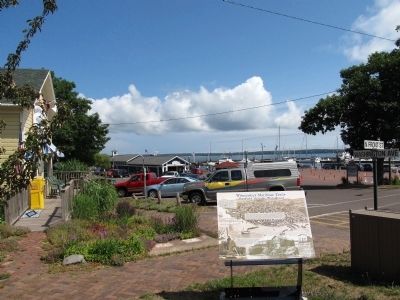
2. Bayfield Historic Waterfront Marker
looking east out toward the marina.
Other nearby markers. At least 8 other markers are within 3 miles of this marker, measured as the crow flies: The Booth Cooperage (within shouting distance of this marker); Memorial to Commercial Fishermen of Bayfield (about 300 feet away, measured in a direct line); Sailor’s Delight (approx. 0.2 miles away); Schooner Pretoria (approx. ¼ mile away); A Turning Point in Place and Time (approx. ¼ mile away); Cultural Fire Returns to Stockton Island (approx. 0.3 miles away); Mooningwaanikaaning (approx. 2½ miles away); Early Vessels (approx. 2.9 miles away). Touch for a list and map of all markers in Bayfield.
Another marker is no longer nearby. Madeline Island (was approx. 2½ miles away but has been permanently removed).
Also see . . . Wisconsin's Maritime Trails. Wisconsin Historical Society (Submitted on July 26, 2012, by Bernard Fisher of Richmond, Virginia.)
Credits. This page was last revised on June 16, 2016. It was originally submitted on July 25, 2012, by Paul Fehrenbach of Richfield, Wisconsin. This page has been viewed 1,045 times since then and 37 times this year. Photos: 1, 2. submitted on July 25, 2012, by Paul Fehrenbach of Richfield, Wisconsin. • Bernard Fisher was the editor who published this page.
