Argyle in Washington County, New York — The American Northeast (Mid-Atlantic)
Kilmer Mill
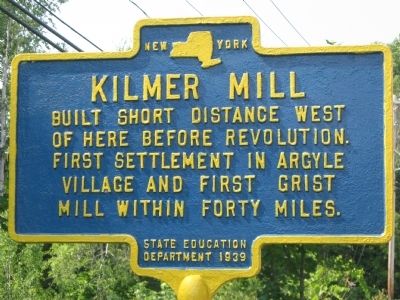
Photographed by Virginia McGreevy, August 16, 2012
1. Kilmer Mill Marker
Erected 1939 by New York State Education Department.
Topics. This historical marker is listed in these topic lists: Colonial Era • Industry & Commerce.
Location. 43° 14.373′ N, 73° 29.505′ W. Marker is in Argyle, New York, in Washington County. It is on Main St (County Route 197) close to Mill Street. Touch for map. Marker is at or near this postal address: 106-110 Main St, Argyle NY 12809, United States of America. Touch for directions.

Regionally, this marker is in Upstate New York and in the Capital District. It is also in the American Northeast and in the Mid-Atlantic. Globally, it is in North America, the Great North Woods, the Western Hemisphere, the Western World, and the Anglosphere. Historically, it finds itself in what was once the Viceroyalty of New France, New Netherland, and one of the original Thirteen Colonies.
Other nearby markers. At least 8 other markers are within 5 miles of this marker, measured
this page online
Another marker is no longer nearby. The Family of John Allen (was approx. 3½ miles away but has been confirmed missing).
Credits. This page was last revised on June 16, 2016. It was originally submitted on August 18, 2012, by Tom McGreevy of Averill Park, New York. This page has been viewed 1,025 times since then and 57 times this year. Photo 1. submitted on August 18, 2012, by Tom McGreevy of Averill Park, New York. • Bill Pfingsten was the editor who published this page.
