North Codorus Township near Spring Grove in York County, Pennsylvania — The American Northeast (Mid-Atlantic)
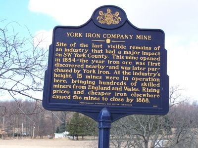
York Iron Company Mine
Erected 1993 by Pennsylvania Historical and Museum Commission.
Topics and series. This historical marker is listed in these topic lists: Industry & Commerce • Natural Resources • Notable Events. In addition, it is included in the Pennsylvania Historical and Museum Commission series list. A significant historical year for this entry is 1854.
Location. 39° 50.918′ N, 76° 48.725′ W. Marker is near Spring Grove, Pennsylvania, in York County. It is in North Codorus Township. Marker is on Hoff Road, half a mile north of Green Valley Road, on the left when traveling north. Touch for map. Marker is in this post office area: Seven Valleys PA 17360, United States of America. Touch for directions.
Other nearby markers. At least 8 other markers are within 3 miles of this marker, measured as the crow flies. St. Paul's (Ziegler's) Lutheran Church (approx. 1.6 miles away); Hanover Junction (approx. 1.9 miles away); Hanover Junction Vital Crossroads (approx. 1.9 miles away); 3-inch Rifles (approx. 1.9 miles away); Birthplace of Commercial Ice Cream Production (approx. 2.2 miles away); Jefferson (approx. 2.6 miles away); Municipal Memorial Hall (approx. 2.6 miles away); Jefferson Public Square (approx. 2.7 miles away).
Credits. This page was last revised on February 7, 2023. It was originally submitted on March 1, 2008, by Bill Pfingsten of Bel Air, Maryland. This page has been viewed 1,735 times since then and 44 times this year. Photos: 1, 2. submitted on March 1, 2008, by Bill Pfingsten of Bel Air, Maryland.

