Near Sharpsburg in Washington County, Maryland — The American Northeast (Mid-Atlantic)
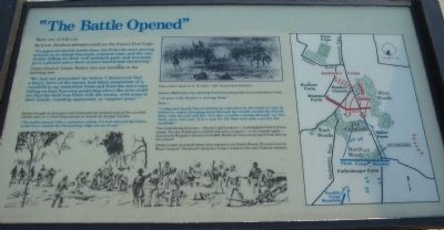
"The Battle Opened"
Dawn was at 5:43 a.m.
By 6 a.m. Southern defenders could see the Union's First Corps:
"In apparent double battle lines, the Federals were moving toward us at charge bayonets, common time, and the sunbeams falling on their well polished guns and bayonets gave a glamor and show at once fearful and entrancing."
Union General Joseph Hooker also saw bayonets in the morning sun:
"We had not proceeded far before I discovered that a heavy force of the enemy had taken possession of a cornfield in my immediate front and from the sun's rays falling on their bayonets projecting above the corn could see that the field was filled with the enemy, with arms in their hands, standing aparently at 'support arms.'"
Hooker brought up 36 cannon and obliterated the northern part of the cornfield and the men in it. First Corps moved on toward the Dunker Church.
"The battle opened with a resolution which, if it had infected McClellen (sic, McClellan) would have carried the Sharpsburg ridge ere set of sun."
General McClellan was watching from his headquarters across Antietam Creek:
"All goes well; Hooker is driving them."
Then -
"A long and steady line of rebel gray, unbroken by the fugitives who flew before us, comes sweeping down through the woods around the church. They raise the yell and fire. It is like a scythe running through our line. 'Now, save, who can.' It is a race for life that each man runs for the cornfield."
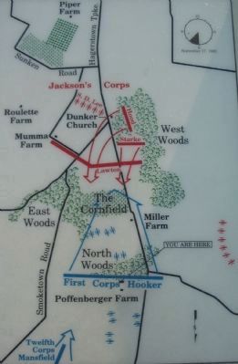
Two Confederate divisions - Starke's and Lawton's - had stopped the first Union attack. But the Northerners rallied and came on again - to be stopped again - this time by Brigadier General John Bell Hood's division charging up from behind the church.
Hooker's men were back where they started in the North Woods. The survivors in Major General "Stonewall" Jackson's Corps waited for the next Federal advance.
Topics. This historical marker is listed in this topic list: War, US Civil.
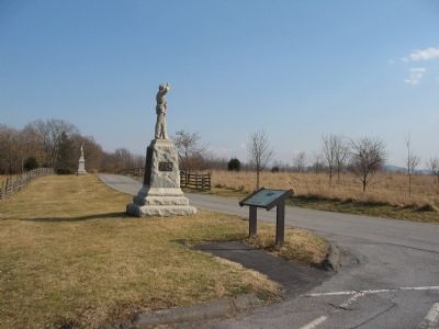
Location. This marker has been replaced by another marker nearby. 39° 29.331′ N, 77° 44.814′ W. Marker is near Sharpsburg, Maryland, in Washington County. Marker is on Mansfield Avenue, on the left when traveling east. Located at the pull off for Stop Two on the driving tour of Antietam Battlefield, the Poffenberger Farm. Touch for map. Marker is in this post office area: Sharpsburg MD 21782, United States of America. Touch for directions.
Other nearby markers. At least 8 other markers are within walking distance of this location. The Culmination of Another Great Tragedy was at Hand (here, next to this marker); 4th Regiment Pennsylvania Reserve Volunteer Corps (a few steps from this marker); "God has indeed remembered us"
(within shouting distance of this marker); Clara Barton (within shouting distance of this marker); a different marker also named Clara Barton (within shouting distance of this marker); 7th Regiment Pennsylvania (within shouting distance of this marker); 1st Corps, 3rd Division, 2nd Brigade Bivouac (within shouting distance of this marker); First Army Corps (within shouting distance of this marker). Touch for a list and map of all markers in Sharpsburg.
More about this marker. The lower portion of the marker contains an illustration of the First Corps artillery in action in the North Woods. The upper center contains a sketch of the 125th Pennsylvania by H.W. Doust. On the right is a map depicting the action at this phase of the battle.
Regarding "The Battle Opened". This marker was replaced by another named The Culmination of Another Great Tragedy (See nearby markers).
Related markers. Click here for a list of markers that are related to this marker. A Virtual Tour by Markers of the North Woods
Also see . . .
1. Antietam Battlefield. National Park Service site. (Submitted on March 2, 2008, by Craig Swain of Leesburg, Virginia.)
2. General Hooker's Report. Antietam on the Web entry:
Hooker never completely filed his report of the battle. An unfinished account was included with the Official Records. Hooker was slightly wounded in the fighting around the cornfield and succeeded in command by General Meade on the field. (Submitted on March 2, 2008, by Craig Swain of Leesburg, Virginia.)

Photographed By Craig Swain, February 9, 2008
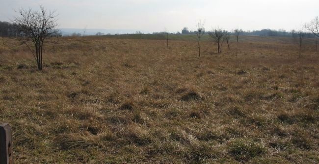
4. Looking "Through" the North Woods toward D.R. Miller's Farm
The North Woods covered the foreground here, looking south from tour stop two (Poffenberger Farm). The cornfield is beyond the second rise in the distance. General Meade (3rd Division) advanced Anderson's and Magilton's Brigades out of the woods and across the open fields as they advanced south to support Doubleday's Divisional attack down the Hagerstown Pike.
Credits. This page was last revised on March 31, 2022. It was originally submitted on March 2, 2008, by Craig Swain of Leesburg, Virginia. This page has been viewed 1,446 times since then and 11 times this year. Photos: 1, 2, 3, 4. submitted on March 2, 2008, by Craig Swain of Leesburg, Virginia.


