Hays in Ellis County, Kansas — The American Midwest (Upper Plains)
Commissary Warehouse
Photographed by William Fischer, Jr., February 20, 2012
1. Commissary Warehouse Marker
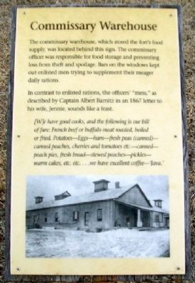
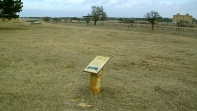
The commissary warehouse, which stored the fort’s food supply, was located behind this sign. The commissary officer was responsible for food storage and preventing loss from theft and spoilage. Bars on the windows kept out enlisted men trying to supplement their meager daily rations.
In contrast to enlisted rations, the officers’ “mess,” as described by Captain Albert Barnitz in an 1867 letter to his wife, Jennie, sounds like a feast.
[W]e have good cooks, and the following is our bill of fare: French beef or buffalo meat roasted, boiled or fried. Potatoes – Eggs – ham – fresh peas (canned) – canned peaches, cherries and tomatoes etc.-canned – peach pies, fresh bread – stewed peaches – pickles – warm cakes, etc. etc…we have excellent coffee – ‘Java.’
Erected by Kansas Historical Society.
Topics. This historical marker is listed in these topic lists: Forts and Castles • Wars, US Indian. A significant historical year for this entry is 1867.
Location. 38° 51.794′ N, 99° 20.565′ W. Marker is in Hays, Kansas, in Ellis County. It can be reached from Highway 183 Alternate. Marker is on the grounds of Fort Hays State
this page online

Regionally, this marker is in the Smoky Hills. It is also in the American Midwest, in the Corn Belt, on the prairies, and on the Southern Plains. Globally, it is in North America, the Western Hemisphere, the Western World, and the Anglosphere. Historically, it finds itself in what was once the Louisiana Purchase.
Other nearby markers. At least 8 other markers are within walking distance of this marker: Time Capsule (a few steps from this marker); Monarch of the Plains (within shouting distance of this marker); Fort Hays (within shouting distance of this marker); Parade Ground (within shouting distance of this marker); Enlisted Barracks (about 300 feet away, measured in a direct line); Officers' Row (about 300 feet away); Fort Hays - Fort Dodge Road Trailhead (about 300 feet away); Elizabeth Bacon Custer (about 300 feet away). Touch for a list and map of all markers in Hays.
Also see . . .
1. Fort Hays State Historic Site.
Photographed by William Fischer, Jr., February 20, 2012
2. Commissary Warehouse Marker
2. Fort Hays State Historic Site. (Submitted on September 23, 2012, by William Fischer, Jr. of Reynoldsburg, Ohio.)
Credits. This page was last revised on October 3, 2022. It was originally submitted on September 23, 2012, by William Fischer, Jr. of Reynoldsburg, Ohio. This page has been viewed 458 times since then and 22 times this year. Photos: 1, 2. submitted on September 23, 2012, by William Fischer, Jr. of Reynoldsburg, Ohio.
