Brunswick in Frederick County, Maryland — The American Northeast (Mid-Atlantic)
One Time Rivals
B&O Railroad and C&O Canal
Photographed by Don Morfe, January 7, 2012
1. One Time Rivals Marker
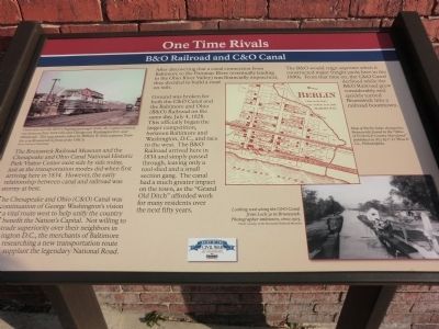
The Brunswick Railroad Museum and the Chesapeake and Ohio Canal National Historic Park Visitor Center exist side by side today, just as the transportation modes did when first arriving here in 1834. However, the early relationship between canal and railroad was stormy at best.
The Chesapeake and Ohio (C&O) Canal was a continuation of George Washington’s vision for a vital route west to help unify the country and to benefit the Nation’s Capitol. Not willing to accept trade superiority over their neighbors in Washington D.C., the merchants of Baltimore began researching a new transportation route to supplant the legendary National Road.
After discovering that a canal connection from Baltimore to the Potomac River (eventually leading to the Ohio River Valley) was financially impractical, they decided to build a road on rails. Ground was broken for both the C&O Canal and the Baltimore and Ohio (B&O) Railroad on the same day, July 4, 1828. This officially began the larger competition, between Baltimore and Washington, D.C., and race to the west. The B&O Railroad arrived here in 1834 and simply passed through, leaving only
this page online
The B&O would reign supreme when it constructed major freight yards here in the 1890’s. From that time on, the C&O Canal declined while the B&O Railroad grew considerably and quickly turned Brunswick into a railroad boomtown.
[Captions:]
From 1923-1971 the B&O's flagship passenger train, the Capitol Limited, ran between New York City and Chicago via Washington D.C. and Pittsburgh. This 1949 picture taken by William W. Rinn captures Train No. 9 in Brunswick in front of the YMCA.
Map of Berlin (later changed to Brunswick) found in the "Atlas of Frederick County Maryland" published in 1873 by C.O. Titus & Co., Philadelphia.
Looking west along the C&O Canal from Lock 30 in Brunswick. Photographer unknown, circa 1905.
Erected 2011 by Heart of the Civil War Heritage Area, Maryland Heritage Areas Authority.
Topics and series. This historical marker is listed in these topic lists: Railroads & Streetcars • Waterways & Vessels. In addition, it

Photographed by Devry Becker Jones (CC0), December 6, 2025
2. One Time Rivals Marker
The marker has weathered but remains generally legible.
Location. 39° 18.784′ N, 77° 37.691′ W. Marker is in Brunswick, Maryland, in Frederick County. It is at the intersection of North Maryland Avenue and West Potomac Street, on the right when traveling north on North Maryland Avenue. This marker is located next to the Brunswick Visitor Center. Touch for map. Marker is at or near this postal address: 40 West Potomac Street, Brunswick MD 21716, United States of America. Touch for directions.

Regionally, this marker is in the Washington Metropolitan Area and in Central Maryland. It is also in the American Mid-Atlantic. Globally, it is in North America, the Western Hemisphere, the Western World, and the Anglosphere. Historically, it finds itself in what was once one of the original Thirteen Colonies and also the Antebellum South.
Other nearby markers. At least 8 other markers are within walking distance of this marker: Brunswick (about 300 feet away, measured in a direct line); Gordon N. Wakefield (about 300 feet away); "The Town Between the Tracks"

Photographed by Don Morfe, January 7, 2012
3. The entrance to the Brunswick Visitor Center
Photographed by Don Morfe, January 7, 2012
4. One Time Rivals Marker
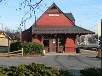
Train Station GPS: 39.3121N 77.6276W

Photographed by Don Morfe, January 7, 2012
5. Mural near the marker
Credits. This page was last revised on December 6, 2025. It was originally submitted on November 5, 2012, by Don Morfe of Baltimore, Maryland. This page has been viewed 820 times since then and 24 times this year. Photos: 1. submitted on November 5, 2012, by Don Morfe of Baltimore, Maryland. 2. submitted on December 6, 2025, by Devry Becker Jones of Washington, District of Columbia. 3, 4, 5. submitted on November 5, 2012, by Don Morfe of Baltimore, Maryland. • Bill Pfingsten was the editor who published this page.
Editor’s want-list for this marker. A wide shot of the marker in context. • Can you help?
