
Near Galena in Cherokee County, Kansas — The American Midwest (Upper Plains)
The Kansas Ozarks
Photographed by William Fischer, Jr., November 21, 2011
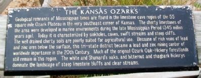
1. The Kansas Ozarks Marker
Geological remnants of Mississippian times are found in the limestone cave region of the 55 square mile Ozark Plateau in the very southeast corner of Kansas. The cherty limestones of the area were developed in marine environments during the late Mississippian Period (345 million years ago). Today it is characterized by sinkholes, caves, swift streams and steep cliffs. The well drained cherty soils are poorly suited for agricultural use. Because of rich veins of lead and zinc below the surface, this tri-state district became a lead and zinc mining center of worldwide importance in the 20th Century. Much of the original Ozark Oak-Hickory forestlands still remain in this region. The white and Shumard's oaks, and bitternut and shagbark hickorys dominate the landscape of steep limestone bluffs and clear streams.
Erected by Southeast Kansas Nature Center.
Topics. This historical marker is listed in these topic lists: Environment • Industry & Commerce.
Location. 37° 2.575′ N, 94° 38.5′ W. Marker is near Galena, Kansas, in Cherokee County. It can be reached from South
this page online

Regionally, this marker is in Eastern Kansas and specifically in Bleeding Kansas Border War Country. It is also in the American Midwest, in the Corn Belt, on the prairies, and on the Southern Plains. Globally, it is in North America, the Western Hemisphere, the Western World, and the Anglosphere. Historically, it finds itself in what was once New Spain and also the Louisiana Purchase.
Other nearby markers. At least 8 other markers are within 3 miles of this marker, measured as the crow flies: War Memorial (approx. 2.2 miles away); Gearhead Curios, Galena, Kansas (approx. 2.3 miles away); Mining And Its Impacts (approx. 2.3 miles away); Galena Chamber of Commerce, Galena, Kansas (approx. 2.3 miles away); Welcome To Galena (approx. 2.3 miles away); Galena Growth And Change (approx. 2.3 miles away); Pappy Litch Park, Galena, Kansas (approx. 2.3 miles away); Route 66 Howard 'Pappy' Litch Park
Photographed by William Fischer, Jr., November 21, 2011
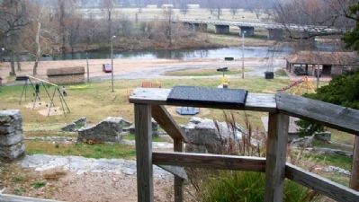
2. The Kansas Ozarks Marker
Also see . . .
1. Southeast Kansas Nature Center, Galena. Kansas Department of Wildlife & Parks website entry (Submitted on November 17, 2012, by William Fischer, Jr. of Reynoldsburg, Ohio.)
2. Lead and Zinc Mining in Kansas. Kansas Geological Survey website entry (Submitted on November 17, 2012, by William Fischer, Jr. of Reynoldsburg, Ohio.)
3. Ozark Plateau. Kansaspedia entry (Submitted on December 9, 2020, by Larry Gertner of New York, New York.)
Credits. This page was last revised on August 26, 2026. It was originally submitted on November 17, 2012, by William Fischer, Jr. of Reynoldsburg, Ohio. This page has been viewed 1,185 times since then and 77 times this year. Photos: 1, 2. submitted on November 17, 2012, by William Fischer, Jr. of Reynoldsburg, Ohio.
