Plymouth in Washington County, North Carolina — The American South (South Atlantic)
Roanoke River Lighthouse
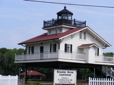
Photographed by Don Morfe, July 17, 2010
1. Roanoke River Lighthouse Marker
Topics and series. This historical marker is listed in these topic lists: Charity & Public Work • Waterways & Vessels. In addition, it is included in the Lighthouses series list. A significant historical year for this entry is 1866.
Location. 35° 51.978′ N, 76° 45.234′ W. Marker is in Plymouth, North Carolina, in Washington County. It is on West Water Street. Touch for map. Marker is in this post office area: Plymouth NC 27962, United States of America. Touch for directions.

Regionally, this marker is in North Carolina’s Coastal Plain. It is also in the American South, specifically in the Upper South, in the Tidewater, and on the Eastern Seaboard. Globally, it is in the North Atlantic Region, North America, the Western Hemisphere, the Western World, and the Anglosphere. Historically, it finds itself in what was once the territory of the Mississippian Culture, one of the original Thirteen Colonies, one of the Confederate States of America, and the Antebellum South.
Other nearby markers. At least 8 other markers
this page online
Another marker is no longer nearby. Battle of Plymouth (was approx. ¼ mile away but has been replaced with another marker now near it).
Credits. This page was last revised on January 8, 2020. It was originally submitted on December 29, 2012, by Don Morfe of Baltimore, Maryland. This page has been viewed 521 times since then and 16 times this year. Photo 1. submitted on December 29, 2012, by Don Morfe of Baltimore, Maryland. • Craig Swain was the editor who published this page.
