Jefferson City in Cole County, Missouri — The American Midwest (Upper Plains)
Jefferson City Greenway:
Lewis and Clark Trailhead Plaza
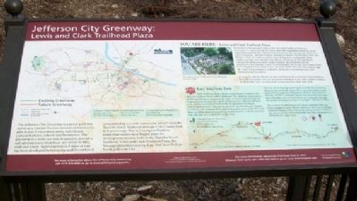
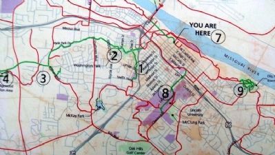
The Jefferson City Greenway is a linear park that serves as a conduit for non-motorized travelers to gain access to recreation areas, natural and cultural features, schools and businesses. The greenway is a multi-use trail designed to provide a safe alternate away from busy city streets to bike, walk and wheel. Approximately 12.8 miles of trail has been developed between 1991 and December of 2009 including a 7.1 mile continuous stretch from the Dunklin Street Trailhead through Cole County Park to Scarborough Way in Covington Gardens residential subdivision. Future plans for development include links to the Dunklin Street Trailhead, Lewis and Clark Trailhead Plaza, the Missouri Riverfront and the Katy Trail State in North Jefferson City.
You Are Here - Lewis and Clark Trailhead Plaza
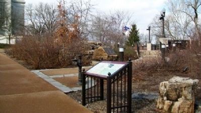
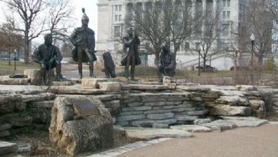
Dedicated in the spring of 2008, Lewis and Clark Trailhead Plaza was developed to commemorate the Lewis and Clark Expedition and to act as an orientation point for the Jefferson City Greenway. The monument, entitled "A Gift to Missouri," includes bronze castings of Captains Meriwether Lewis and William Clark, the leaders of the Corps of Discovery in 1804-1806; York, Clark's personal slave and the only African American on the expedition; George Drouillard, a notable hunter, trapper and interpreter for the expedition; and Seaman, Lewis' Newfoundland-breed dog. These figures have been integrated into a man-made limestone bluff with water flowing through the rocks and plantings to symbolize Missouri's varied landscapes and plentiful water resources.
In keeping with the themes of trails and discovery, Lewis and Clark Trailhead Plaza also provides a bicycle area and orientation to the state Capitol complex, the Jefferson City Greenway trail system and Katy Trail State Park.
Katy Trail State Park
Katy Trail State Park is built on the former corridor of the Missouri-Kansas-Texas (MKT) Railroad. The Misosuri Department of Natural Resources acquired the right-of-way in 1986 through the National Trails System Act, which allows inactive railroad corridors to be used as recreation trails while being banked for future transportation needs. The park is open for 225 miles from St. Charles to Clinton. The majority of the trail follows the route of the Missouri River so hikers and bicyclists often find themselves with the river on one side and towering bluffs on the other.
The trail travels through many types of landscapes including dense forests, wetlands, deep valleys, remnant prairies, open pastureland and gently rolling fields. With so many types of habitats, wildlife is abundant. Katy Trail State Park also takes users through a slice of rural history as it meanders through the small towns that once thrived along the river corridor.
The section of trail between St. Charles and Booneville has been designated as an official segment of the Lewis and Clark National Historic Trail. The entire trail is considered part of the American Discovery Trail and it has been designated as a Millenium Legacy Trail.
Erected by Jefferson City Parks and Recreation and Missouri Department of Natural Resources.
Topics and series. This historical marker is listed in these topic lists: Exploration • Parks & Recreational Areas. In addition, it is included in the Lewis & Clark Expedition series list. A significant historical month for this entry is December 2009.
Location. 38° 34.695′ N, 92° 10.283′ W. Marker is in Jefferson City, Missouri, in Cole County. Marker is at the intersection of Jefferson Street and Capitol Avenue, on the left when traveling north on Jefferson Street. Touch for map. Marker is in this post office area: Jefferson City MO 65101, United States of America. Touch for directions.
Other nearby markers. At least 8 other markers are within walking distance of this marker. Corps of Discovery (a few steps from this marker); The Missouri River Valley as a Transportation Corridor (a few steps from this marker); The Corps of Discovery in the Jefferson City Area (within shouting distance of this marker); Replica of the Statue of Liberty (within shouting distance of this marker); Missouri Governor's Mansion (about 600 feet away, measured in a direct line); Thomas Jefferson (about 600 feet away); Missouri Motor Carriers Association Building (about 600 feet away); Missouri Petroleum Marketers and Convenience Store Association (about 600 feet away). Touch for a list and map of all markers in Jefferson City.
Also see . . .
1. Lewis and Clark National Historic Trail. National Park Service website entry (Submitted on January 2, 2013, by William Fischer, Jr. of Scranton, Pennsylvania.)
2. American Discovery Trail Society. (Submitted on January 2, 2013, by William Fischer, Jr. of Scranton, Pennsylvania.)
Credits. This page was last revised on March 29, 2024. It was originally submitted on January 2, 2013, by William Fischer, Jr. of Scranton, Pennsylvania. This page has been viewed 558 times since then and 19 times this year. Photos: 1, 2, 3. submitted on January 2, 2013, by William Fischer, Jr. of Scranton, Pennsylvania. 4. submitted on January 3, 2013, by William Fischer, Jr. of Scranton, Pennsylvania.


