Cox's Point Park
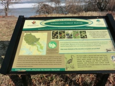
Shoreline Forest Buffer
An Ecosystem is a community of living and non-living things that are dependent on each other. Elements of this ecosystem include the aquatic wetland plants, and the forest buffer trees and shrubs planted along the shoreline. How many elements of the shoreline ecosystem can you find?
Back River watershed has 73 miles of streams located in Baltimore County and Baltimore City. The watershed includes the stream systems of Herring Run, Stemmers Run, Red House Run, Briens Run, and Bread and Cheese Creek. All of the streams in the watershed drain to the tidal portion of Back River. The watershed includes the communities of Stoneleigh, Parkville, Overlea, Hamilton, Belair-Edison, Frankfort, Rosedale, and Essex.
This forest buffer is planted with trees and shrubs that are native to the Mid-Atlantic region. These native plants provide essential water quality benefits by trapping and filtering sediments, nutrients, and chemicals from the surface runoff. Native plants also provide habitat for animals on land and in the water.
Erected by Baltimore County Department of Environmental Protection and Resource Management.
Topics. This historical
Location. 39° 17.616′ N, 76° 27.882′ W. Marker is in Essex, Maryland, in Baltimore County. Marker is on Riverside Drive. Cox's Point Park is at the end of Riverside Drive. Touch for map. Marker is in this post office area: Essex MD 21221, United States of America. Touch for directions.
Other nearby markers. At least 8 other markers are within 2 miles of this marker, measured as the crow flies. North Point Battlefield (approx. 1.4 miles away); Aquila Randall Monument (approx. 1.4 miles away); North Point State Park - Sept. 12, 1814 Battlefield (approx. 1.4 miles away); Battle Acre (approx. 1˝ miles away); Hitting Home (approx. 1˝ miles away); Delay Tactic (approx. 1˝ miles away); Proud of Our Stand (approx. 1˝ miles away); To Honor the Heroes (approx. 1˝ miles away).
Credits. This page was last revised on June 16, 2016. It was originally submitted on January 28, 2013, by Don Morfe of Baltimore, Maryland. This page has been viewed 663 times since then and 60 times this year. Photos: 1, 2, 3. submitted on January 28, 2013, by Don Morfe of Baltimore, Maryland. • Bill Pfingsten was the editor who published this page.


