Near Nancy in Pulaski County, Kentucky — The American South (East South Central)
Archaeology and the Mill Springs Battlefield
Photographed by David Graff, April 26, 2012
1. Archaeology and the Mill Springs Battlefield Marker
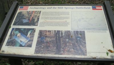
For several years the Mill Springs Battlefield Association, with the help of professional archeologists, has located and mapped artifacts on the battlefield. The type of artifact, their placement, and density is used to determine the units present during the battle and their movements. Heavy concentrations of spent bullets, for example, indicate where the heaviest fighting took place, Uniform buttons, the type of ammunition, and other artifacts can help identify the regiment.
The red stakes at the head of the ravine mark the location of artifacts recovered from this portion of the battlefield. The line of stakes going up the hill marks the firing location of the 10th Indiana; the Union regiment firing at that Confederate unit.
Metal Detecting On The Battlefield Is Forbidden. Locating artifacts with metal detectors is a powerful tool in uncovering information about the battlefield. But its usefulness relies on proper use. All metal detecting on the battlefield is conducted under very controlled conditions and is undertaken only with the supervision of a professional archaeologist. Please help protect the archaeological resources
this page online
Erected by Mill Springs Battlefield Association.
Topics. This historical marker is listed in this topic list: War, US Civil.
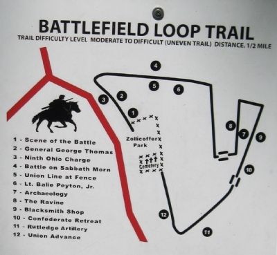
Location. 37° 3.351′ N, 84° 44.231′ W. Marker is near Nancy, Kentucky, in Pulaski County. It can be reached from State Road 235 0.1 miles south of State Route 761, on the left when traveling south. Marker is Station 7 on the Battlefield Loop Trail at Auto Tour Stop 2 - Zollicoffer Park. Position is in forest and was estimated using Bing Maps. Refer to photo of Battlefield Loop Trail. Touch for map. Marker is in this post office area: Nancy KY 42544, United States of America. Touch for directions.

Regionally, this marker is in the Lake Cumberland Region. It is also in the American South, specifically in the Upper South, in Appalachia, and specifically in Southern Appalachia. Globally, it is in North America, the Western Hemisphere, the Western World, and the Anglosphere. Historically, it finds itself in what was once the territory of the Mississippian Culture and also the

Photographed by David Graff, April 26, 2012
2. Archaeology and the Mill Springs Battlefield Marker
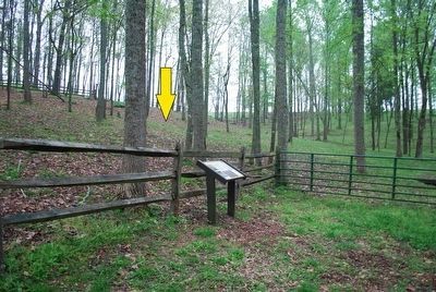
Marker is on the trail along the edge of the ravine to the left. This view is to the north.
Other nearby markers. At least 8 other markers are within walking distance of this marker: The Ravine (a few steps from this marker); The Blacksmith Shop (within shouting distance of this marker); Balie Peyton, Jr. (1833-1862) (about 400 feet away, measured in a direct line); Confederate Retreat (about 500 feet away); Confederate Mass Grave Memorial (about 600 feet away); Confederate Dead (about 600 feet away); "Confederate Mass Grave" (about 600 feet away); Dawn of Battle (about 600 feet away). Touch for a list and map of all markers in Nancy.
More about this marker. No archeological stakes were seen in this area at the time of this visit.
The following illustrations are on this marker:
Photo Top Left: The location of each artifact, be it a bullet, a button, or an unidentified fragment of metal, is marked with a stake.
Photo Bottom Left: Detailed notes are taken, recording data that will be used later for analysis.
Photo Center: Artifacts on this part of the battlefield were located using modern metal detectors.
Map Top Right: Each artifact is mapped. The resulting map shows how the battle was fought. Each number
Photographed by Brandon Fletcher, April 1, 2012
3. Archaeology and the Mill Springs Battlefield Marker
Archaeological dig took place inside this fence behind the marker.
Also see . . . Battle of Mills Spring. Wikipedia entry (Submitted on October 30, 2022, by Larry Gertner of New York, New York.)
Photographed by David Graff, April 26, 2012
4. Battlefield Loop Trail Map
This is Marker 7 - Archaeology
Credits. This page was last revised on October 30, 2022. It was originally submitted on February 6, 2013, by David Graff of Halifax, Nova Scotia. This page has been viewed 968 times since then and 49 times this year. Photos: 1, 2. submitted on February 6, 2013, by David Graff of Halifax, Nova Scotia. 3. submitted on September 16, 2015, by Brandon Fletcher of Chattanooga, Tennessee. 4. submitted on February 6, 2013, by David Graff of Halifax, Nova Scotia. • Craig Swain was the editor who published this page.
