Lawrenceburg in Lawrence County, Tennessee — The American South (East South Central)
Trail of Tears
Bell Removal Route
Photographed by Judith Barber, February 4, 2013
1. Trail of Tears Marker
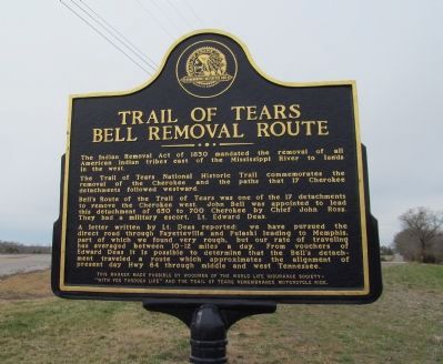
The Trail of Tears National Historic Trail commemorates the removal of the Cherokee and the paths that 17 Cherokee detachments followed westward.
Bell’s Route of the Trail of Tears was one of the 17 detachments to remove the Cherokee west. John Bell was appointed to lead this detachment of 650 to 700 Cherokee by Chief John Ross. They had a military escort, Lt. Edward Deas.
A letter written by Lt. Deas reported: we have pursued the direct road through Fayetteville and Pulaski leading to Memphis, part of which we found very rough, but our rate of traveling has averaged between 10 – 12 miles a day. From vouchers of Edward Deas it is possible to determine that the Bell’s detachment traveled a route which approximates the alignment of present day Hwy 64 through middle and west Tennessee.
"With you through Life" and the Trail of Tears Remembrance Motorcycle ride.
Erected by Woodmen of the World.
this page online
Topics and series. This historical marker is listed in this topic list: Indigenous Peoples and Communities. In addition, it is included in the Trail of Tears series list. A significant historical year for this entry is 1830.
Location. 35° 13.229′ N, 87° 13.84′ W. Marker is in Lawrenceburg, Tennessee, in Lawrence County. It is at the intersection of Lawrenceburg Highway (U.S. 64) and Pulaski Highway (Tennessee Route 15), on the right when traveling west on Lawrenceburg Highway. Touch for map. Marker is at or near this postal address: 4865 Pulaski Hwy, Lawrenceburg TN 38464, United States of America. Touch for directions.

Regionally, this marker is in Middle Tennessee and in the Highland Rim. It is also in the American South, specifically in the Upper South, in Appalachia, and specifically in Southern Appalachia. Globally, it is in North America, the Western Hemisphere, the Western World, and the Anglosphere. Historically, it finds itself in what was once the territory of the Mississippian Culture, one of the Confederate States of America, and the Antebellum South.
Other nearby markers. At least 8 other markers are within
Photographed by Judith Barber, February 4, 2013
2. Trail of Tears Marker
Credits. This page was last revised on June 16, 2016. It was originally submitted on February 7, 2013, by Judith Barber of Marietta, Georgia. This page has been viewed 1,244 times since then and 43 times this year. Photos: 1, 2. submitted on February 7, 2013, by Judith Barber of Marietta, Georgia. • Bernard Fisher was the editor who published this page.
