Carroll-South Hilton in Baltimore, Maryland — The American Northeast (Mid-Atlantic)
Bridging Gwynns Falls
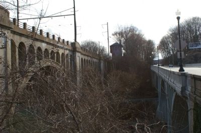
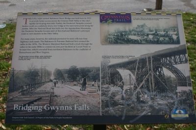
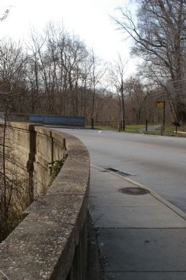
The lofty, triple-arched Baltimore Street Bridge was built here in 1932 to provide better access across the Gwynns Falls Valley to the city's rapidly developing west side. Earlier, the Frederick Turnpike crossed farther south on a relatively short, low bridge at the narrowest point along the stream. After the National Road was built over the Appalachian Mountains, the Frederick Turnpike became part of this road and Baltimore's principal route to new markets in the Ohio Valley.
For many years, however, the railroads proved to be more efficient than highways and canals. The Baltimore & Potomac Railroad first crossed the valley in the 1870s. The Western Maryland Railroad built a track through the valley in the early 1900s to connect its new port facilities at Locust Point to its main line, which extended from northwest Baltimore to the coalfields of and West Virginia.
Erected by Gwynns Falls Trail Council.
Topics and series. This historical marker is listed in these topic lists: Bridges & Viaducts • Roads & Vehicles • Waterways & Vessels. In addition, it is included in the Maryland, Gwynns Falls Trail, and the The Historic National Road series lists. A significant historical year for this entry is 1932.
Location. 39° 17.271′ N, 76° 39.846′ W. Marker is in Baltimore, Maryland. It is in Carroll-South Hilton. Marker is on West Baltimore Street, on the right when traveling west. Touch for map. Marker is at or near this postal address: 2884 W Baltimore St, Baltimore MD 21223, United States of America. Touch for directions.
Other nearby markers. At least 8 other markers are within walking distance of this marker. Early Transportation Routes (about 500 feet away, measured in a direct line); Memorial to John E. Burbage (approx. 0.4 miles away); Gwynns Falls Park at Frederick Avenue (approx. half a mile away); Ellicott Flour Mills (approx. half a mile away); Gwynns Falls Valley (approx. half a mile away); Rowhouses: a Baltimore Tradition (approx. half a mile away); Mt. Olivet Cemetery (approx. 0.6 miles away); Early Industries (approx. ¾ mile away). Touch for a list and map of all markers in Baltimore.
More about this marker. [Illustration, upper right]:
In the early 1800s the Fairview Inn served farmers, merchants and others traveling the Frederick Turnpike.
[Photograph, lower left]:
The Edmondson Avenue Bridge, under construction in 1909, would carry one of the early trolley lines crossing the valley.
[Photograph, lower right]:
A train crosses the railroad bridge as the Baltimore Street Bridge is being constructed in 1932.
Also see . . .
1. Image of the marker. (Submitted on March 18, 2008, by Christopher Busta-Peck of Shaker Heights, Ohio.)
2. Gwynns Falls Trail Council. (Submitted on March 18, 2008, by Christopher Busta-Peck of Shaker Heights, Ohio.)
3. Image of the Fairview Inn, circa 1900. The Fairview Inn is pictured in the illustration at the top of the marker. (Submitted on March 19, 2008, by Christopher Busta-Peck of Shaker Heights, Ohio.)

Photographed By Christopher Busta-Peck, March 17, 2008
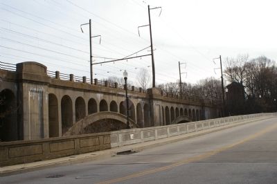
4. The Baltimore and Potomac Railroad (now Amtrak) and West Baltimore Street bridges
The bridge on the left was built in 1873 as part of the Baltimore and Potomac Railroad. The bridge, now owned by Amtrak, is along the Baltimore-Washington end of their busy, high-speed Northeast Corridor route.
Credits. This page was last revised on February 20, 2021. It was originally submitted on March 18, 2008, by Christopher Busta-Peck of Shaker Heights, Ohio. This page has been viewed 2,485 times since then and 32 times this year. Photos: 1. submitted on March 18, 2008, by Christopher Busta-Peck of Shaker Heights, Ohio. 2. submitted on March 19, 2008, by Christopher Busta-Peck of Shaker Heights, Ohio. 3. submitted on March 18, 2008, by Christopher Busta-Peck of Shaker Heights, Ohio. 4. submitted on March 19, 2008, by Christopher Busta-Peck of Shaker Heights, Ohio.


