Near Odanah in Ashland County, Wisconsin — The American Midwest (Great Lakes)
The Bad River
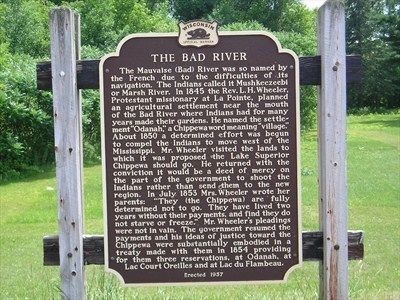
Photographed by Rich Eggleston, July 11, 2006
1. The Bad River Marker
this page online
Erected 1957 by Wisconsin Historical Society. (Marker Number 70.)
Topics. This historical marker is listed in these topic lists: Indigenous Peoples and Communities • Settlements & Settlers. A significant historical year for this entry is 1845.
Location. Marker has been permanently removed. It was located near 46° 36.712′ N, 90° 41.696′ W. Marker was near Odanah, Wisconsin, in Ashland County. It was at the intersection of U.S. 2 and Old Odanah Road, on the left when traveling west on U.S. 2. Touch for map. Marker was in this post office area: Odanah WI 54861, United States of America.
We have been informed that this marker is no longer there and will not be replaced. This page is an archival view of what was.
Regionally, this marker was on the North Shore. It was also in the American Midwest, in the Corn Belt, and on Lake Superior’s South Shore Region. Globally, it was in North America, in the Great North Woods, on the Great Lakes, in the Western Hemisphere, in the Western World, and in the Anglosphere. Historically, it found itself in what was once the Viceroyalty of New France, the territory

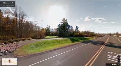
Google Street View (©2016 Google Street View), October 2015.
2. View to West from US 2
The support posts for the marker are still visible at this roadside pullout
Other nearby markers. At least 8 other markers are within 11 miles of this location, measured as the crow flies: Fleet Admiral William D. Leahy (approx. 8 miles away); Schooner Lucerne (approx. 8.1 miles away); Doctor Edwin Ellis (approx. 8.6 miles away); Northland College (approx. 8.7 miles away); Soo Line Decapod - 950 (approx. 9.1 miles away); Security Savings Bank (approx. 9.2 miles away); Washburn, The Monolith City (approx. 10.2 miles away); Bank of Washburn (approx. 10.2 miles away).
More about this marker. This marker was permanently removed by the Wisconsin Historical Society on the request of the Bad River Band of Ojibwe.
Additional commentary.
1. Marker Removed
The Wisconsin Historical Society, in their Official List of Wisconsin's State Historic Markers dated September 16, 2013, states "Marker Removed - Language Obsolete" for The Bad River marker. Images from Google Street View indicate that the marker was removed some time prior to September 2008; the support posts for the marker still remain as of October 2015.
— Submitted January 24, 2016, by Duane Hall of Abilene, Texas.
Credits. This page was last revised on February 15, 2024. It was originally submitted on March 7, 2013, by Rich Eggleston of Fitchburg, Wisconsin. This page has been viewed 2,436 times since then and 163 times this year. Photos: 1. submitted on March 7, 2013, by Rich Eggleston of Fitchburg, Wisconsin. 2. submitted on May 31, 2016, by Duane Hall of Abilene, Texas. • Bernard Fisher was the editor who published this page.
Editor’s want-list for this marker. Wide shot of marker and its surroundings. • Can you help?
