Columbia Heights in Northwest Washington in Washington, District of Columbia — The American Northeast (Mid-Atlantic)
Campus to Army Camps and Back Again
Meridian Hill Park, National Historic Landmark
| — | National Park Service, U.S. Department of the Interior | — |
Photographed by Allen C. Browne, March 2, 2013
1. Campus to Army Camps and Back Again Marker
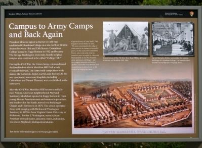
During the Civil War, the Union Army commandeered the farmland on which Meridian Hill Park would eventually be built. The Army built camps there with names like Cameron, Relief, Carver, and Barclay. As the war continued, numerous hospitals, including Columbian and Mount Pleasant, were established in the same area.
After the Civil War, Meridian Hill became a middle-class African American neighborhood. Wayland Seminary, which had opened in Foggy Bottom to train young African American men and women as preachers and teachers for the South, moved to a building at Chapin and 15th Streets in 1875. The school operated there until merging with Richmond Theological Seminary in 1899 to form Virginia Union University in Richmond. Booker T. Washington, noted African American political leader,educator, orator, and author, was one
this page online
For more information go to: www.nps.gov/mehi
Captain Grover of New York's 76th Regiment wrote home in 1861, "We encamped in the edge of what must be in summer a beautiful grove, on the estate of Commodore Porter, a few rods only from his mansion now occupied as a hospital. But beautiful as was the situation... snow and mud, cold fingers and toes, empty stomachs and soiled cloths concealed every beauty, and compelled us to attend only the work of arranging the camp."
Erected by National Park Service, U.S. Department of the Interior.
Topics and series. This historical marker is listed in these topic lists: African Americans • Education • War, US Civil. In addition, it is included in the Former U.S. Presidents: #05 James Monroe, the Historically Black Colleges and Universities, and the National Historic Landmarks series lists. A significant historical year for this entry is 1821.
Location. 38° 55.383′ N, 77° 2.124′ W. Marker is in Northwest Washington in Washington, District of Columbia. It is in Columbia Heights. It can be reached from 15th Street Northwest south of Euclid Street
Photographed by Devry Becker Jones (CC0), July 16, 2020
2. Campus to Army Camps and Back Again Marker

Regionally, this marker is in the Washington Metropolitan Area. It is also in the American Northeast, in the Upper South, in the Mid-Atlantic, in the Tidewater, and in the Chesapeake Bay Region. Globally, it is in North America, the Western Hemisphere, the Western World, and the Anglosphere.
Other nearby markers. At least 8 other markers are within walking distance of this marker: Mansions, Parks, and People (within shouting distance of this marker); A Hilltop for Heroes and Horse Thieves (about 300 feet away, measured in a direct line); Visionary and Park Champion (about 300 feet away); Creating the "City Beautiful" (about 300 feet away); Design Challenges (about 300 feet away); Park Designers (about 300 feet away); Life on the Park (about 300 feet away); Embassy of the Republic of Lithuania / Lithuania's March to Freedom (about 400 feet away). Touch for a list and map of all markers in Northwest Washington.
Also see . . . www.nps.gov/mehi. This URL appears on the Marker. (Submitted on March 16, 2013, by Allen C. Browne of Silver Spring, Maryland.)
Credits. This page was last revised on January 30, 2023. It was originally submitted on March 16, 2013, by Allen C. Browne of Silver Spring, Maryland. This page has been viewed 938 times since then and 59 times this year. Photos: 1. submitted on March 16, 2013, by Allen C. Browne of Silver Spring, Maryland. 2. submitted on July 16, 2020, by Devry Becker Jones of Washington, District of Columbia. • Craig Swain was the editor who published this page.
