Belle and Mayo Islands in Richmond, Virginia — The American South (Mid-Atlantic)
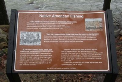
Native American Fishing
There was a seasonal fishing village at the broad, flat, eastern end of this island. It was located about where you came onto the island from the foot bridge. Comprised only of twig huts and fish drying racks, it was set up every year but lacked the usual defensive barricades. In order that all the tribes could safely capture and preserve food, tribal leaders, arranged annual treaties to prohibit warfare when men went fishing.
At the base of the various rapids, native boys would prove their manhood by attempting to ride enormous pregnant sturgeon. The best sites were where big rocks and channels of whitewater rapids met calm, flat water --- such as at the beginning of the rapids where the 14th St Bridge is today. These 8 foot long fish would seek out calm pools in which to lay eggs or rest before mowing up through the next whitewater channels.
The 15 and 16 year old boys would get nods of approval from the observant elders… and appreciative glances from local girls, if they could hold on. Success might lead to finding a wife! If they fell off, or broke a finger, or if the fish just sank to the bottom, they got the ultimate humiliation: the elders would turn their backs, the girls would giggle…and there was no possibility of a social life for the next year.
It is interesting to note that in 2012 several large sturgeon were spotted below the 14th St. Bridge.
Erected 2012 by James River Park System.
Topics. This historical marker is listed in this topic list: Native Americans. A significant historical year for this entry is 2012.
Location. 37° 31.822′ N, 77° 27.179′ W. Marker is in Richmond, Virginia. It is in Belle and Mayo Islands. Marker can be reached from Tredegar Street, 0.3 miles west of South 5th Street. Located on Belle Isle which can be reached via a pedestrian bridge from the north bank of the river. Touch for map. Marker is at or near this postal address: 470 Tredegar Street, Richmond VA 23219, United States of America. Touch for directions.
Other nearby markers. At least 8 other markers are within walking distance of this marker. Hollywood Rapids (within shouting distance of this marker); Canons (sic) and Corpses (about 500 feet away, measured in a direct line); Ironworks Oil House (about 600 feet away); Cannon over the Camp (about 600 feet away); Belle Isle Rolling Milling and Slitting Manufactory (about 600 feet away); Historic Belle Isle (about 600 feet away); The Power of Moving Water (about 700 feet away); Quarry Equipment (about 700 feet away). Touch for a list and map of all markers in Richmond.
Credits. This page was last revised on February 1, 2023. It was originally submitted on April 1, 2013, by Bernard Fisher of Richmond, Virginia. This page has been viewed 664 times since then and 39 times this year. Photos: 1, 2, 3. submitted on April 1, 2013, by Bernard Fisher of Richmond, Virginia.


