Salina in Mayes County, Oklahoma — The American South (West South Central)
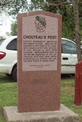
Chouteau's Post
Erected 1995 by Oklahoma Historical Society. (Marker Number 158.)
Topics and series. This historical marker is listed in these topic lists: Native Americans • Settlements & Settlers. In addition, it is included in the Oklahoma Historical Society series list. A significant historical year for this entry is 1802.
Location. 36° 17.561′ N, 95° 8.923′ W. Marker is in Salina, Oklahoma, in Mayes County. Marker is at the intersection of East Ferry Street (State Highway 20) and South Saltwell Street, on the right when traveling east on East Ferry Street. Located in the parking lot on the southwest corner of the intersection. Touch for map. Marker is at or near this postal address: 203 South Saltwell Street, Salina OK 74365, United States of America. Touch for directions.
Other nearby markers. At least 8 other markers are within 14 miles of this marker, measured as the crow flies. Battle of Locust Grove (approx. 6˝ miles away); Veterans Memorial (approx. 9.4 miles away); Nathaniel Hale Pryor (approx. 9.4 miles away); Cabin Creek (approx. 13.7 miles away); 1st Kansas Colored Volunteer Infantry (approx. 13.7 miles away); Confederate Soldiers (approx. 13.7 miles away); 6th Kansas Cavalry (approx. 13.7 miles away); 14th Kansas Cavalry (approx. 13.7 miles away).
Credits. This page was last revised on June 16, 2016. It was originally submitted on April 16, 2013, by Michael Manning of Woodlawn, Tennessee. This page has been viewed 739 times since then and 58 times this year. Photo 1. submitted on April 16, 2013, by Michael Manning of Woodlawn, Tennessee. • Bernard Fisher was the editor who published this page.
Editor’s want-list for this marker. Wide shot of marker and its surroundings. • Can you help?
