Jeannette in Westmoreland County, Pennsylvania — The American Northeast (Mid-Atlantic)
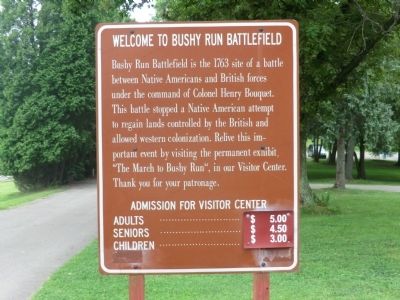
Welcome to Bushy Run Battlefield
Topics. This historical marker is listed in this topic list: War, French and Indian. A significant historical year for this entry is 1763.
Location. 40° 21.433′ N, 79° 37.55′ W. Marker is in Jeannette, Pennsylvania, in Westmoreland County. Marker is on Bushy Run Road (Pennsylvania Route 993). The marker is located on the grounds of the Bushy Run Battlefield Park. Touch for map. Marker is in this post office area: Jeannette PA 15644, United States of America. Touch for directions.
Other nearby markers. At least 8 other markers are within 5 miles of this marker, measured as the crow flies. Ambush (about 300 feet away, measured in a direct line); Bushy Run Battlefield (about 500 feet away); Pontiac's War (about 500 feet away); Bushy Run (approx. 3.2 miles away); Fort Walthour (approx. 4 miles away); Toll House (approx. 4.6 miles away); Delmont (approx. 4.7 miles away); New Salem Borough 100th Anniversary (approx. 4.7 miles away). Touch for a list and map of all markers in Jeannette.
Also see . . . Bushy Run Battlefield website. (Submitted on August 7, 2013, by Bill Pfingsten of Bel Air, Maryland.)
Credits. This page was last revised on June 16, 2016. It was originally submitted on August 7, 2013, by Don Morfe of Baltimore, Maryland. This page has been viewed 548 times since then and 17 times this year. Photos: 1, 2, 3. submitted on August 7, 2013, by Don Morfe of Baltimore, Maryland. • Bill Pfingsten was the editor who published this page.


