Ottawa in Franklin County, Kansas — The American Midwest (Upper Plains)
Main Street, 200 Block South
Historic Ottawa Tour Stop 4
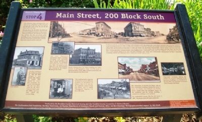
The panoramic photo reproduced here was taken by J.C. Bandholtz in 1909. Panoramas were the rage at that time. The view takes in the 100 block south on the left and the 200 block south on the right.
The east side of the 200 block was placed on the National Register of Historic Places in 1972 due to its unique concentration of 19th century commercial structures. Since that time, the block has suffered the loss of several major buildings. These include the Zellner Building at the northeast corner, the Rohrbaugh building in the center of the block, and the North American Hotel coffee shop towards the south end.
The first building on the northwest corner of 2nd and Main belonged to town founder Isaac Kalloch. Its second floor housed the town's first newspaper, the Western Home Journal. The site was then used for the First National Bank until the 1960s, and was later called the Lawyers Bldg.
Like many Midwestern downtowns, Ottawa buildings developed with mercantile use on the ground floor and offices upstairs. The lithograph above shows the corner in the late 1860s. The photo to the right shows the same building now dwarfed by the Zellner Building to the north.
Besides clothing stores, the Zellner building also held a number of photographer's shops over the years. A structural failure in the 1980s caused its destruction; the site was replaced with Haley Park.
This small portable shop can be found in several different locations in old photos of Ottawa. Here it is seen on the southwest corner of 2nd and Main, and is called "Bloodgood's Popcorn." It also sold candy.
In Hometown U.S.A., an American Heritage book published in 1975, the authors refer to the Ottawa pictured in this panoramic portrait as "a not inconsiderable town in 1909. A county seat, a producer of soap, flour, furniture and carriages, served by two railroads, it was home to 7,600 people. Planted firmly on the corner of Main and Second was the Peoples National Bank, with the Dickey and Porter land office upstairs; the elk's head [which marked the local meeting rooms of the Elks Lodge]...had its antlers tipped with light bulbs and must have been a 24-hour attraction. Among the bank's near neighbors were a barbershop, a music store, and a millinery. By all appearances, Ottawa was a town entirely typical of its time and place; buildings more sturdy than architecturally distinguished, the horse comfortably co-existing with the few motorcars in town, and no one outside without a hat."
"Plaza-style" Christmas lighting that outlines the Victorian silhouettes of the downtown buildings was introduced in the late 1970s. The prototype was Kansas City's Country Club Plaza.
Visit
the Old Depot Museum
135 W. Tecumseh
Tuesday-Saturday 10-4
Sunday 1-4
785.242.1250
www.olddepotmuseum.org
Erected by Franklin County Historical Society and Franklin County Convention & Visitors Bureau.
Topics. This historical marker is listed in these topic lists: Industry & Commerce • Roads & Vehicles • Settlements & Settlers. A significant historical year for this entry is 1909.
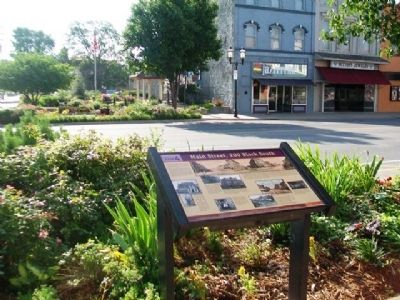
Location. 38° 36.938′ N, 95° 16.123′ W. Marker is in Ottawa, Kansas, in Franklin County. Marker is at the intersection of Main Street and 2nd Street, on the right when traveling south on Main Street. Touch for map. Marker is at or near this postal address: 202 Main Street, Ottawa KS 66067, United States of America. Touch for directions.
Other nearby markers. At least 8 other markers are within walking distance of this marker. Shepherd & McQuesten Building (a few steps from this marker); Pickrell Building (within shouting distance of this marker); The Down Town Ottawa Historic District (within shouting distance of this marker); Franklin County Courthouse (about 500 feet away, measured in a direct line); a different marker also named The Franklin County Courthouse (about 800 feet away); Main Street, 400 Block South (approx. 0.2 miles away); Marais de Cygnes River (approx. ¼ mile away); Main Street, 500 Block South and City Park (approx. 0.3 miles away). Touch for a list and map of all markers in Ottawa.
Also see . . .
1. Historic Ottawa Central Business District National Register Nomination. (Submitted on August 9, 2013, by William Fischer, Jr. of Scranton, Pennsylvania.)
2. Visit Ottawa, Kansas. (Submitted on August 9, 2013, by William Fischer, Jr. of Scranton, Pennsylvania.)
3. Franklin County, Kansas, Historical Portal. (Submitted on August 9, 2013, by William Fischer, Jr. of Scranton, Pennsylvania.)
Credits. This page was last revised on September 3, 2020. It was originally submitted on August 9, 2013, by William Fischer, Jr. of Scranton, Pennsylvania. This page has been viewed 531 times since then and 11 times this year. Photos: 1, 2. submitted on August 9, 2013, by William Fischer, Jr. of Scranton, Pennsylvania.

