Bath in Beaufort County, North Carolina — The American South (South Atlantic)
Colonial Bath
Photographed by Mike Wintermantel, August 10, 2013
1. Colonial Bath Marker
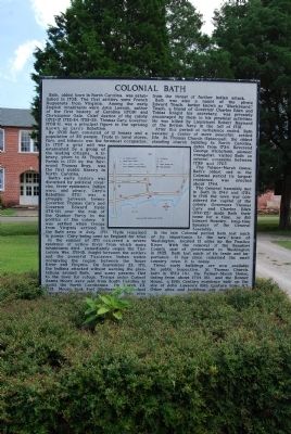
Bath’s early history was disturbed by political rivalries, fever epidemics, Indian wars, and piracy. Cary’s Rebellion (1711) was a struggle between former Governor Thomas Cary and Governor Edward Hyde (1711-12) over the role of the Quaker Party in the politics of the colony. It was settled when troops from Virginia arrived in the Bath area in July, 1711. Hyde remained in power, Cary being sent to England for trial.
In the summer of 1711 occurred a severe epidemic of yellow fever from which many inhabitants died. Immediately began the Tuscarora War, 1711-15, fought between the settlers and the powerful Tuscarora Indian nation occupying the region between the Neuse River and Virginia. On September 22, 1711, the Indians attacked without warning the plantations around Bath, and many persons fled to the town for refuge. Troops under Colonel James Moore were sent from South Carolina to assist the North Carolinians. On March 23, 1713, Moore took Fort Nooherooka, principal Tuscarora stronghold, freeing the Bath area from the threat of further Indian attack.
Bath was also a haunt of the pirate
this page online
After this period of turbulence ended, Bath became a center of more peaceful, settled life. St. Thomas Church (Episcopal), the oldest standing church building in North Carolina, dates from 1734. Reverend George Whitefield, pioneer evangelist, visited Bath on several occasions between 1739 and 1765. The Palmer-Marsh House, Bath’s oldest and in the colonial period its largest residence, was erected about 1744. The General Assembly met in Bath in 1744 and 1752. In 1746 the town was considered for capital of the colony. Governors Thomas Cary and Charles Eden (1714-22) made Bath their home for a time, as did Edward Moseley, long-time Speaker of the General Assembly.
In the late Colonial period Bath lost much of its importance to the new town of Washington, located 12 miles up the Pamlico River. With the removal of the Beaufort County seat of government to Washington in 1785,
Photographed by Mike Wintermantel, August 10, 2013
2. Colonial Bath Marker
Erected 1962. (Marker Number BB-1.)
Topics and series. This historical marker is listed in these topic lists: Education • Settlements & Settlers • Wars, US Indian. In addition, it is included in the North Carolina Division of Archives and History series list. A significant historical month for this entry is March 1709.
Location. 35° 28.624′ N, 76° 48.732′ W. Marker is in Bath, North Carolina, in Beaufort County. It can be reached from the intersection of Carteret Street (State Highway 92) and Harding Street. Located at the State Historic Center in Bath. Touch for map. Marker is in this post office area: Bath NC 27808, United States of America. Touch for directions.

Regionally, this marker is in the Coastal Plain. It is also in the American South, specifically in the Upper South, in the Tidewater, and on the Eastern Seaboard. Globally, it is in the North Atlantic Region, North America, the Western Hemisphere, the Western World, and the Anglosphere. Historically, it finds itself in what was once the territory of the Mississippian Culture, one of the original Thirteen Colonies, one of the Confederate States of America, and the Antebellum South.
Other nearby markers. At least 8 other markers are within walking distance of this marker: Historic Bath (here, next to this marker); Palmer-Marsh House (about 500 feet away, measured in a direct line); First Public Library (about 500 feet away); James Adams Floating Theatre (about 600 feet away); Matthew Rowan (about 600 feet away); a different marker also named Colonial Bath (about 600 feet away); First Post Road (about 700 feet away); Port of Bath and Thomas Harding (approx. 0.2 miles away). Touch for a list and map of all markers in Bath.
Credits. This page was last revised on October 4, 2024. It was originally submitted on August 12, 2013, by Mike Wintermantel of Pittsburgh, Pennsylvania. This page has been viewed 955 times since then and 47 times this year. Photos: 1, 2. submitted on August 12, 2013, by Mike Wintermantel of Pittsburgh, Pennsylvania.
