Luzern, Switzerland — Central Europe (the Alps)
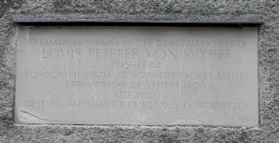
Louis Pfyffer von Wyher
Louis Pfyffer von Wyher
1716 – 1802
Topograph Ersteller schweizerischer Reliefs
Erbaut 1709 Erweitert 1808
Seit 1807
Gesellschaftshaus der Herren zu Schuetzen
RFB 1977
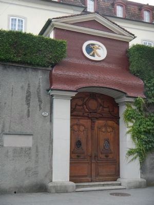
Former country house of Lieutenant General
Louis Pfyffer von Wyher
1716 - 1802
Cartographer and the creator of Swiss relief maps
Built 1709, Expanded 1808
since 1807
Quarters of the Lords of the Guard
Topics. This historical marker is listed in this topic list: Notable Buildings. A significant historical year for this entry is 1716.
Location. 47° 3.138′ N, 8° 18.167′ E. Marker is in Luzern. Marker is on Löwengraben, on the left when traveling west. Touch for map. Marker is at or near this postal address: Löwengraben 24, Luzern 6004, Switzerland. Touch for directions.
Other nearby markers. At least 8 other markers are within walking distance of this marker. The Mills Gate (here, next to this marker); Mühlenplatz (Mill Place) (within shouting distance of this marker); Dr. Jur. Kasimir Pfyffer (within shouting distance of this marker); The Spreuer Bridge Paintings (within shouting distance of this marker); Metzgerrainli 6 (about 120 meters away, measured in a direct line); The Sonnenberg House in Zoepfli (about 120 meters away); The Spreuer Bridge (about 120 meters away); "Sweet Spot" (about 150 meters away). Touch for a list and map of all markers in Luzern.
Also see . . . Franz Ludwig Pfyffer (1716–1802). Terrainmodels.com's short biography of Pfyffer von Wyher: ...The Swiss Franz Ludwig Pyffer von Wyher served in the French army as lieutenant general. In Paris, Pfyffer came in contact with the French terrain modelling school. After his retirement in 1769, he returned to his hometown Lucerne and began surveying a part of Central Switzerland around the Lake Lucerne. This area lacked accurate terrain maps until then. By using the latest measurement techniques available at that time, he spent 24 years from 1762 to 1786 to create maps and a large terrain model....Pfyffers terrain model is considered the world’s oldest large-scale landscape relief and a pioneering work of Swiss cartography. It can be visited at the Glacier Garden in Lucerne. (Submitted on August 25, 2013.)
Credits. This page was last revised on August 21, 2020. It was originally submitted on August 16, 2013, by Barry Swackhamer of Brentwood, California. This page has been viewed 491 times since then and 17 times this year. Photos: 1, 2. submitted on August 16, 2013, by Barry Swackhamer of Brentwood, California. • Andrew Ruppenstein was the editor who published this page.

