Near Monroe in Overton County, Tennessee — The American South (East South Central)
Camp Myers
Confederate Induction Center
Photographed by Don Morfe, July 22, 2013
1. Camp Myers Marker
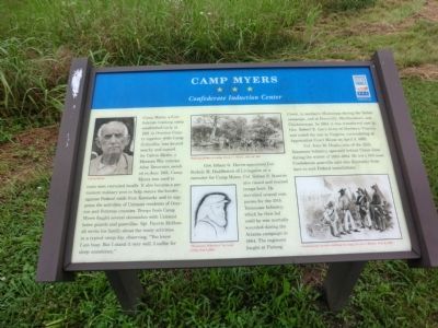
Gov. Isham G. Harris appointed Col. Stokely H. Huddleston of Livingston as a recruiter for Camp Myers. Col. Sidney S. Stanton also raised and trained troops here. He recruited several companies for the 25th Tennessee Infantry, which he then led until he was mortally wounded during the Atlanta campaign in 1864. The regiment fought at Fishing Creek, in northern Mississippi during the Shiloh campaign,
this page online
Col. John M. Hughs, also of the 25th Tennessee Infantry, operated behind Union lines during the winter of 1863-1864. He led a 300-man Confederate guerrilla unit into Kentucky from here to raid Federal installations.
Erected by Tennessee Civil War Trails.
Topics and series. This historical marker is listed in this topic list: War, US Civil. In addition, it is included in the Tennessee Civil War Trails series list. A significant historical date for this entry is April 9, 1865.
Location. 36° 26.934′ N, 85° 12.816′ W. Marker is near Monroe, Tennessee, in Overton County. It is on Byrdstown Highway (SR111) north of Beaty Swamp Road, on the right when traveling north. Touch for map. Marker is in this post office area: Monroe TN 38573, United States of America. Touch for directions.

Regionally, this marker is in the Cumberland Plateau and in the Highland Rim. It is also in the American South, specifically in the Upper South,
Photographed by Don Morfe, July 22, 2013
2. Camp Myers Marker
Other nearby markers. At least 8 other markers are within 8 miles of this marker, measured as the crow flies: Alpine School (approx. 3.8 miles away); Albert Houston Roberts (approx. 3.8 miles away); "Tennessee Lead" (approx. 6.4 miles away); a different marker also named Albert Houston Roberts (approx. 7.3 miles away); Birthplace of Lester Raymond Flatt (approx. 7.6 miles away); Overton County Veterans Memorial (approx. 7.6 miles away); Staff Sergeant Loval E. Ayers (approx. 7.6 miles away); Specialist 4 James T. Davis (approx. 7.6 miles away).
Photographed by Don Morfe, July 22, 2013
3. Camp Myers Marker
Photographed by Don Morfe, July 22, 2013
4. Camp Myers Marker
Credits. This page was last revised on November 11, 2024. It was originally submitted on September 2, 2013, by Don Morfe of Baltimore, Maryland. This page has been viewed 2,080 times since then and 130 times this year. Photos: 1, 2, 3, 4. submitted on September 2, 2013, by Don Morfe of Baltimore, Maryland. • Al Wolf was the editor who published this page.
