Clarksville in Montgomery County, Tennessee — The American South (East South Central)
Surrender of Clarksville
Union Occupation
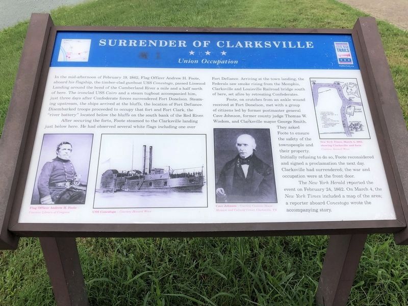
After securing the forts, Foote steamed to the Clarksville landing just below here. He had observed several white flags including one over Fort Defiance. Arriving at the town landing, the Federals saw smoke rising from the Memphis, Clarksville and Louisville Railroad bridge south of here, set afire by retreating Confederates.
Foote, on crutches from an ankle wound received at Fort Donelson, met with a group of citizens led by former postmaster general Cave Johnson, former county judge Thomas W. Wisdom, and Clarksville mayor George Smith. They asked Foote to ensure the safety of the townspeople and their property. Initially refusing to do so, Foote reconsidered and signed a proclamation the next day. Clarksville had surrendered; the war and occupation were at the front door.
The New York Herald reported the event on February 24, 1862. On March 4, the New York Times included a map of the area; a reporter aboard Conestoga wrote the accompanying story.
(captions)
Flag Officer Andrew H. Foote - Courtesy Library of Congress
USS Conestoga - Courtesy Howard Winn
Cave Johnson - Courtesy Customs House Museum and Cultural Center, Clarksville, TN
New York Times, March 4, 1862, showing Clarksville and forts Courtesy Howard Winn
Erected by Tennessee Civil War Trails.
Topics and series. This historical marker is listed in this topic list: War, US Civil. In addition, it is included in the Tennessee Civil War Trails series list. A significant historical date for this entry is February 19, 2001.
Location. 36° 31.745′ N, 87° 21.849′ W. Marker is in Clarksville, Tennessee, in Montgomery County. Marker can be reached from the intersection of North Riverside Drive (Bypass U.S. 41A) and College Street (Tennessee Route 48), on the left when traveling north. Located along the Clarksville Riverwalk. Touch for map. Marker is in this post office area: Clarksville TN 37040, United States of America. Touch for directions.
Other nearby markers. At least 8 other markers are within walking distance of this marker. Lafayette's Tour (a few steps from this marker); Freedom Light (about 800 feet away, measured in a direct line); Clarksville in the Civil War (approx. 0.2 miles away); First Court House (approx. 0.2 miles away); John Montgomery Statue (approx. ¼ mile away); Town Spring (approx. ¼ mile away); Frank Spencer Sutton (approx. ¼ mile away); Whitfield, Bradley & Co. (approx. ¼ mile away). Touch for a list and map of all markers in Clarksville.
Credits. This page was last revised on September 5, 2022. It was originally submitted on September 13, 2013, by Don Morfe of Baltimore, Maryland. This page has been viewed 915 times since then and 42 times this year. Photos: 1. submitted on September 4, 2022, by Duane and Tracy Marsteller of Murfreesboro, Tennessee. 2, 3. submitted on September 13, 2013, by Don Morfe of Baltimore, Maryland. • Bernard Fisher was the editor who published this page.


