Autaugaville in Autauga County, Alabama — The American South (East South Central)
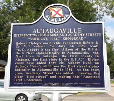
Autaugaville
Intersection of Autauga and Academy Streets
| — | "America's First Crossroad" | — |
Photographed by Mark Hilton, August 26, 2013
1. Autaugaville Marker
Erected 2008 by Autauga County Heritage Association, Autauga Area Community Foundation, Alabama Historical Association.
Topics and series. This historical marker is listed in these topic lists: Roads & Vehicles • Settlements & Settlers. In addition, it is included in the Alabama Historical Association, and the Believe It or Not series lists. A significant historical date for this entry is July 31, 1935.
Location. 32° 25.889′ N, 86° 39.205′ W. Marker is in Autaugaville, Alabama, in Autauga County. It is at the intersection of South Autauga Street and Academy Street, on the right when traveling south on South
this page online

Regionally, this marker is in the Tri-Counties River Region. It is also in the American South, specifically in the Deep South, and in the Black Belt. Globally, it is in North America, a Gulf of Mexico state, the Western Hemisphere, the Western World, and the Anglosphere. Historically, it finds itself in what was once New Spain, the territory of the Mississippian Culture, one of the Confederate States of America, and the Antebellum South.
Other nearby markers. At least 8 other markers are within 8 miles of this marker, measured as the crow flies: Albert J. Pickett (1810-1858) (approx. 1½ miles away); Taylor Family Cemetery (approx. 2.8 miles away); Robinson-DeJarnette Cemetery (approx. 5.3 miles away); William D. Smith Family Cemetery (approx. 5.4 miles away); Holy Ground Battlefield (approx. 5.8 miles away); Old Mulberry Schoolhouse (approx. 7.4 miles away); Greater Mallard's Chapel A.M.E. Church Cemetery (approx. 7.4 miles away); Ivy Creek Cemetery
Photographed by Mark Hilton, August 26, 2013
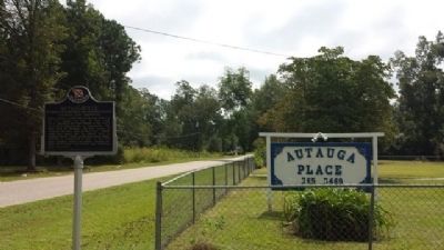
2. Autaugaville Marker
Another marker is no longer nearby. Albert J. Pickett (was approx. 1½ miles away but has been permanently removed).
Credits. This page was last revised on March 20, 2019. It was originally submitted on September 26, 2013, by Mark Hilton of Montgomery, Alabama. This page has been viewed 3,610 times since then and 207 times this year. Photos: 1, 2. submitted on September 26, 2013, by Mark Hilton of Montgomery, Alabama. • Bernard Fisher was the editor who published this page.
