Near Berkeley Springs in Morgan County, West Virginia — The American South (Appalachia)
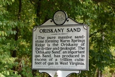
Oriskany Sand
Erected 1963 by The West Virginia Centennial Committee of the Oil and Natural Gas Industry, West Virginia Historical Commission.
Topics and series. This historical marker is listed in these topic lists: Natural Features • Natural Resources. In addition, it is included in the West Virginia Archives and History series list.
Location. 39° 30.217′ N, 78° 17.817′ W. Marker is near Berkeley Springs, West Virginia, in Morgan County. Marker is on Cacapon Lodge Drive, one mile west of Valley Road (U.S. 522). Touch for map. Marker is at or near this postal address: 818 Cacapon Lodge Dr, Berkeley Springs WV 25411, United States of America. Touch for directions.
Other nearby markers. At least 8 other markers are within 4 miles of this marker, measured as the crow flies. Cacapon State Park Picnic Grills (approx. 0.2 miles away); Cacapon State Park Playground Equipment (approx. ¼ mile away); Welcome to Cacapon State Park (approx. 0.3 miles away); Cacapon State Park (approx. 0.3 miles away); Ridge Fish Hatchery (approx. 2.9 miles away); Cacapon Mountain Overlook (approx. 3.4 miles away); Overlook at Cacapon State Park (approx. 3.4 miles away); West Virginia (Morgan County) / Virginia (approx. 4 miles away). Touch for a list and map of all markers in Berkeley Springs.
Credits. This page was last revised on September 23, 2021. It was originally submitted on October 3, 2013, by Tom Fuchs of Greenbelt, Maryland. This page has been viewed 614 times since then and 23 times this year. Photos: 1, 2. submitted on October 3, 2013, by Tom Fuchs of Greenbelt, Maryland.
Editor’s want-list for this marker. Wide shot of the marker • Can you help?

