Phenix City in Russell County, Alabama — The American South (East South Central)
Union Night Attack Down Summerville Road
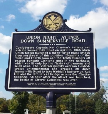
Photographed by Mark Hilton, October 5, 2013
1. Union Night Attack Down Summerville Road Marker
Erected 2004 by The Historic Chattahoochee Commission And the Phenix City-Russell County Chamber of Commerce.
Topics. This historical marker is listed in this topic list: War, US Civil. A significant historical month for this entry is April 1825.
Location. 32° 29.156′ N, 85° 0.463′ W. Marker is in Phenix City, Alabama, in Russell County. It is at the intersection of Summerville Road and 26th Street, on the right when traveling north on Summerville Road. Touch for map. Marker is at or near this postal address: 2608 Summerville
this page online

Regionally, this marker is in Greater Columbus. It is also in the American South, specifically in the Deep South, and in the Black Belt. Globally, it is in North America, a Gulf of Mexico state, the Western Hemisphere, the Western World, and the Anglosphere. Historically, it finds itself in what was once the territory of the Mississippian Culture, one of the Confederate States of America, and the Antebellum South.
Other nearby markers. At least 8 other markers are within 2 miles of this marker, measured as the crow flies: Susie E. Allen Elementary School (approx. ¾ mile away); Allen Temple A.M.E. Church / Grant Chapel A.M.E. Church (approx. ¾ mile away); Albert Love Patterson (approx. one mile away); Before The Battle / Battle Of Girard (approx. one mile away); City Mills (approx. one mile away in Georgia); Camp Conrad (approx. 1.2 miles away in Georgia); TSYS (approx. 1.2 miles away in Georgia); Mills (approx. 1.2 miles away in Georgia). Touch for a list and map of all markers in Phenix City.
Another marker is no longer nearby. Red Hill Batteries
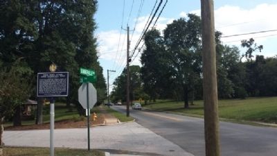
Photographed by Mark Hilton, October 5, 2013
2. Down Summerville Road
Related markers. Click here for a list of markers that are related to this marker.
Credits. This page was last revised on June 16, 2016. It was originally submitted on October 5, 2013, by Mark Hilton of Montgomery, Alabama. This page has been viewed 1,647 times since then and 63 times this year. Photos: 1, 2. submitted on October 5, 2013, by Mark Hilton of Montgomery, Alabama. • Bernard Fisher was the editor who published this page.
