Near Chili in Coshocton County, Ohio — The American Midwest (Great Lakes)
Dr. William Edgar Lower Co-Founder of Cleveland Clinic
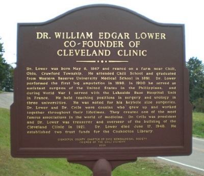
Photographed by Peter Arthur Lower Rodgers, 2008
1. Dr. William Edgar Lower Co/Founder of Cleveland Clinic Marker
Erected 2004 by Coshocton County Chapter of Ohio Genealogical Society. Friends of Chili Vicinity.
Topics. This historical marker is listed in this topic list: Science & Medicine. A significant historical month for this entry is May 1803.
Location. 40° 21.433′ N, 81° 45.822′ W.
this page online

Regionally, this marker is in Amish Country. It is also in the American Midwest, in Appalachia, and specifically in Northern Appalachia. Globally, it is in North America, the Western Hemisphere, the Western World, and the Anglosphere. Historically, it finds itself in what was once the Haudenosaunee (Iroquois) Confederacy, the territory of the Mississippian Culture, and the Northwest Territory.
Other nearby markers. At least 8 other markers are within 6 miles of this marker, measured as the crow flies: George Goovers (approx. 1.1 miles away); North Appalachian Experimental Watershed (approx. 1.8 miles away); Richard Mandley (approx. 2 miles away); Everett H. Jr. Wolford (approx. 3.8 miles away); Koquechagachton (approx. 4½ miles away); West Lafayette (approx. 5 miles away); Troop Train Accident Memorial (approx. 5.6 miles away); Pennsylvania National Guard Troop Train Accident, September 1950 (approx. 5.6 miles away).
Also see . . . "Find a Grave" ::. (Submitted on October 9, 2013.)
Credits. This page was last revised on November 5, 2016. It was originally submitted on October 8, 2013, by Peter Arthur Lower Rodgers of Elkhart, Indiana. This page has been viewed 1,361 times since then and 63 times this year. Photo 1. submitted on October 8, 2013, by Peter Arthur Lower Rodgers of Elkhart, Indiana. • Al Wolf was the editor who published this page.
Editor’s want-list for this marker. Wide view photo showing entire marker. Any other information would be appreciated. Please add to this marker. • Can you help?
