Clinton in Henry County, Missouri — The American Midwest (Upper Plains)
Henry County
[Side A]
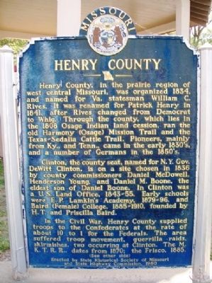
Henry County, in the prairie region of west central Missouri, was organized 1834, and named for Va. statesman William C. Rives. It was renamed for Patrick Henry in 1841, after Rives changed from Democrat to Whig. Through the county, which lies in the 1808 Osage Indian land cession, ran the old Harmony (Osage) Mission Trail and the Texas-Sedalia Cattle Trail. Pioneers, mainly from Ky., and Tenn., came in the early 1830's, and a number of Germans in the 1850's.
Clinton, the county seat, named for N.Y. Gov. DeWitt Clinton, is on a site chosen in 1836 by county commissioners Daniel McDowell, Henderson Young, and Daniel M. Boone, the eldest son of Daniel Boone. In Clinton was a U.S. Land Office, 1843-55. Early schools were E. P. Lamkin's Academy, 1879-96, and Baird (Female) College, 1885-1910, founded by H. T. and Priscilla Baird.
In the Civil War, Henry County supplied troops to the Confederates at the rate of about 10 to 1 for the Federals. The area suffered troop movement, guerrilla raids, skirmishes, two occurring at Clinton. The M.K.T.R.R., dates from 1870; the Frisco, 1885.
(See other side)
[Side B]
(Continued from other side)
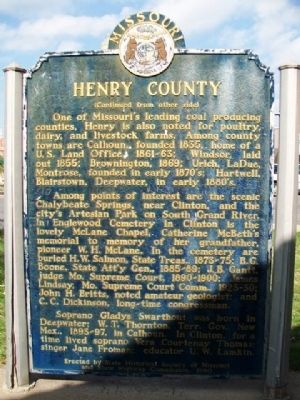
One of Missouri's leading coal producing counties, Henry is also noted for poultry, dairy, and livestock farms. Among county towns are Calhoun, founded 1835, home of a U.S. Land Office, 1861-63; Windsor, laid out 1855; Brownington, 1869; Urich, LaDue, Montrose, founded in early 1870's; Hartwell, Blairstown, Deepwater, in early 1880's.
Among points of interest are the scenic Chalybeate Springs, near Clinton, and the city's Artesian Park on South Grand River. In Englewood Cemetery in Clinton is the lovely McLane Chapel, Catherine McBeth's memorial to memory of her grandfather, pioneer W. H. McLane. In the cemetery are buried H. W. Salmon, State Treas., 1873-75; B. G. Boone, State Att'y Gen., 1885-89; J. B. Gantt, judge Mo. Supreme Court, 1890-1900; James Lindsay, Mo. Supreme Court Comm., 1923-30; John H. Britts, noted amateur geologist; and C. C. Dickinson, long-time congressman.
Soprano Gladys Swarthout was born in Deepwater; W. T. Thornton, Terr. Gov., New Mex., 1893-97, in Calhoun. In Clinton, for a time lived soprano Vera Courtenay Thomas; singer Jane Froman; educator U. W. Lamkin.
Erected 1960 by State Historical Society of Missouri and State Highway Commission.
Topics and series. This historical marker is listed in these topic lists: Industry & Commerce • Railroads & Streetcars • Settlements & Settlers • War, US Civil. In addition, it is included in the Missouri, The State Historical Society of series list. A significant historical year for this entry is 1834.
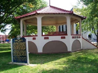
Location. 38° 22.229′ N, 93° 46.647′ W. Marker is in Clinton, Missouri, in Henry County. Marker is at the intersection of Washington Street and Franklin Street, on the left when traveling south on Washington Street. Marker is at the northwest corner of the county courthouse grounds, next to the gazebo. Touch for map. Marker is at or near this postal address: 100 West Franklin Street, Clinton MO 64735, United States of America. Touch for directions.
Other nearby markers. At least 5 other markers are within walking distance of this marker. The Anheuser-Busch Building (within shouting distance of this marker); September 11, 2001 (about 300 feet away, measured in a direct line); Baby Chick Capital of the World (about 400 feet away); Brown Mfg. Co. (about 400 feet away); Poague Building Explosion Victims (about 600 feet away).
Also see . . .
1. Henry County, Missouri, Official Website. (Submitted on October 20, 2013, by William Fischer, Jr. of Scranton, Pennsylvania.)
2. Henry County, Missouri, Genealogy. (Submitted on October 20, 2013, by William Fischer, Jr. of Scranton, Pennsylvania.)
Credits. This page was last revised on June 16, 2016. It was originally submitted on October 20, 2013, by William Fischer, Jr. of Scranton, Pennsylvania. This page has been viewed 716 times since then and 31 times this year. Photos: 1, 2, 3. submitted on October 20, 2013, by William Fischer, Jr. of Scranton, Pennsylvania.


