Near Sharpsburg in Washington County, Maryland — The American Northeast (Mid-Atlantic)
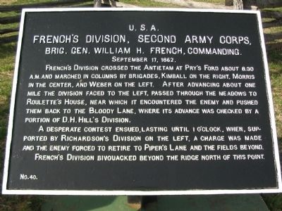
French's Division, Second Army Corps
French's Division, Second Army Corps,
Brig. Gen. William H. French, Commanding.
September 17, 1862.
French's Division crossed the Antietam at Pry's Ford about 8:30 a.m. and marched in columns by brigades, Kimball on the right, Morris in the center, and Weber on the left. After advancing about one mile the division faced to the left, passed through the meadows to Roulette's House, near which it encountered the enemy and pushed them back to the Bloody Lane, where its advance was checked by a portion of D.H. Hill's Division.
A desperate contest ensued, lasting until 1 o'clock, when, supported by Richardson's Division on the left, a charge was made and the enemy forced to retire to Piper's Lane and the fields beyond.
French's Division bivouacked beyond the ridge north of this point.
Erected by Antietam Battlefield Board. (Marker Number 40.)
Topics and series. This historical marker is listed in this topic list: War, US Civil. In addition, it is included in the Antietam Campaign War Department Markers series list. A significant historical month for this entry is September 1786.
Location. 39° 28.288′ N, 77° 44.448′ W. Marker is near Sharpsburg, Maryland, in Washington County. Marker is on Richardson Avenue , on the left when traveling east. Located in a Federal tablet cluster on the northwestern end of the Sunken Road. Touch for map. Marker is in this post office area: Sharpsburg MD 21782, United States of America. Touch for directions.
Other nearby markers. At least 8 other markers are within walking distance of this marker. Second Army Corps (here, next to this marker); Jackson's Command (a few steps from this marker); 5th Maryland Infantry (a few steps from this marker); a different marker also named Second Army Corps (a few steps from this marker); 130th Pennsylvania Volunteer Infantry (a few steps from this marker); a different marker also named Second Army Corps (within shouting distance of this marker); Sixth Army Corps (within shouting distance of this marker); 1st Delaware Volunteers (within shouting distance of this marker). Touch for a list and map of all markers in Sharpsburg.
Related markers. Click here for a list of markers that are related to this marker. French's Division Tablets and Monuments
Also see . . .
1. Antietam Battlefield. National Park Service site. (Submitted on April 7, 2008, by Craig Swain of Leesburg, Virginia.)
2. 3rd Division, II Corps. French, a 1837 graduate of West Point, simplifies the terrible fighting along the Sunken Road in his official report: ...without waiting for the new regiments to recover from the disorder incident to their long march in

Photographed By Craig Swain
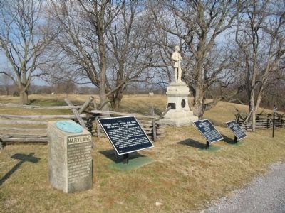
2. Monuments and Markers on the Northern End of the Sunken Road
From left to right: The 5th Maryland Infantry Monument, French's Division Tablet (Number 40), Weber's Brigade Tablet (Number 43), Morris' Brigade Tablet (Number 42), and the 130th Pennsylvania Infantry Monument.

Photographed By Craig Swain, March 29, 2008
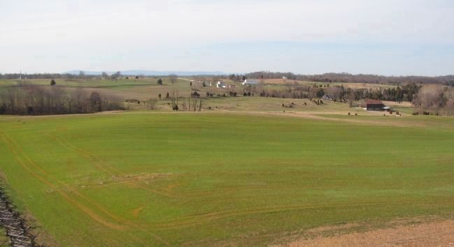
3. Approach of French's Division
From the observation tower at the east end of the Sunken Road, looking to the north. On the right, the rusty roofed barn stands next to the Roulette House. The Roulette Farm Lane runs from near that barn back to the sunken road, passing along the trees in the upper left. In the center distance are the white buildings of the Mumma Farm. The division advanced from the broken terrain beyond the right of the photo, up to the Roulette Farm. With a column of brigades in each in line, the division then moved forward toward the Sunken Road, using the Roulette Farm Lane as the axis of advance.
Credits. This page was last revised on September 29, 2017. It was originally submitted on April 7, 2008, by Craig Swain of Leesburg, Virginia. This page has been viewed 1,111 times since then and 13 times this year. Photos: 1. submitted on April 7, 2008, by Craig Swain of Leesburg, Virginia. 2. submitted on April 5, 2008, by Craig Swain of Leesburg, Virginia. 3. submitted on April 7, 2008, by Craig Swain of Leesburg, Virginia.
