Shasta Lake in Shasta County, California — The American West (Pacific Coastal)
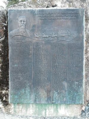
Pioneers Who “Held the Ribbons”
Bass Hill
In Loving Memory to the These Pioneers who “Held the Ribbons” but have Turned the Bend in the Road.
One of the Best Known and Beloved Men in California.
Willianson Lyncoya Smith
Aug. 6, 1830, born on a plantation on the James River, Bedford Co. VA. Named “Lyncoya: by President Andrew Jackson. 1832, family settled in Pike Co. Mo., Apr. 25, 1850, left Pike Co. Mo. with McPike & Strothers Express Line for California. Aug. 6, 1850, arrived in Placerville Calif. 1851. Continuously connected with U.S. Mail until 1892. Railroad between Sacramento & Portland was completed on Dec. 17, 1887. July 1854, carried the first U.S. Mail on horseback, from Jacksonville, to Canyonville, Ore. May 31, 1902, died at his home, West & Tehama Sts. Redding, Calif.
James E. Birch, first stage driver in California & organizer of the California Stage Co. Sept. 12, 1857, lost at sea on the mail steamer Central America.
J.B. Crandall, pioneer stage driver, from 1849, covering Calif. Ore. & Nev. June 11, 1857, drove the first stage over the Sierra Nevada Mts. Nov. 24, 1872, eight miles from Los Angeles, thrown from his stage, was kicked by the wheel horse, ending his life.
W.F. Hall & W.H. Hall
Stage drivers from 1849.
Marshall McCummings
Aug. 1851, drove the first stage from Sacramento to Shasta, Monroe & Feld proprietors.
Daniel Masten Cawley
July 14, 1852, born in N.H. Sept. 1, 1858, drove the first stage over the Siskiyou Mt. for the California Stage Co. Dec. 17, 1887, drove the last stage over Siskiyou for the California Oregon Idaho Stage Co. Oct. 15, 1901, died in Yreka, California.
Andrew Jackson Bacon
Joseph Henry Bacon
This Stage Driver’s Monument marks the Sacramento road where it connects with U.S Highway 99
Erected by Mae Helene Bacon Bogge, niece of Willianson Lyncoya Smith,
Bass Hill, August 6, 1920, centennial of the birth of W. L. Smith.
List of Names
Adams, A.C. • Backman, Daniel • Baird, Albert • Bartle, Jack • Basham, Henry • Beard, George • Becker, Albert • Beaughan, N.T.J. • Bell, James • Blackburn, Jas W. • Bloomfield, Isaacs • Boyce, John H.• Bradley, Amos • Bradley, Mike • Brewster, L.L. • Bridcard, James • Buick, John • Burk, Harry • Burnette, Thomas • Burt, William • Camden, John • Carmer, Rube • Chadbourne, Dave • Chase, George L. • Chase, James V. • Clough, Joseph L. • Combs, Charles • Comstock, James • Cooley,
M. Craddock, John • Creamer, Chas. N. • Crowell, Albert • Culverhouse, Jerry • Curtis, Dave • Curtis, Edward J. • Curtis, Thomas • Cushing E.S. • Davis, Perry O. Decker, Albert • Dockery, Lewis A. • Dow, Lorenzo • Driver, John R. • Drout, George • Dunnegan, William • Eddings, Nofton • Ellery, Elias • Finch, George W. • Finchley, Walter • Finnicum, James D. • Fiock, Charles • Frost, Geo • Garvey, Mike • Gaston, Jack • Gerard, Louis • Giddings, Ab • Giddings, Henry • Glenn, Robert M. • Goodwin, Joseph F. • Gordiner, C.W. • Graham, Edward • Hall, William • Hallick, John C. • Heath, Richard • Henry, W.J, • Hovey, Frank • Howe, John C. • Hughes, Charles W. • Hungerford, Z.N. Jenkins, W.R. • Kennedy, William • Kies, James Henry • Kies, John • King, Andrew G. • Laird, Charles • Lawrence, William • Lewis, Charles • Lewis, E.J. • Luce, James L. • Lynch, James • Mack, John B. • Major, John N. • Martin, John • Mason, Joe • Mathews, Milo • Mathews, William H, • Mayhew, William • McConnell, Charles • McGuffey, John • McGurie, Mike • McInerney, T.J. • McManus, Frank C. • Minthorn, Hiram P. • Montgomery, Zack • Morrison, Henry P. • Morse, Andy • Palmer, Herman C. • Parker, E.G. • Parks, Erskin • Pratt, Newton • Pratt, Warren • Pryor, Alfred L. • Quadlin, David • Reynolds, John E. • Richards, Green
• Robbins, Dan • Robbins, Jared • Roberts, George • Rolfe, Charles H. • Scammon, Gus • Smith, A. • Smith, C.V. • Smith, Franck M. • Smithson, James S. • Spaulding, Asher D. • Spaulding, Melvin J. • Strauser, Joseph M. • Sullaway, John W. • Swatka, Harry • Talbert, William S. • Tice, Fred • Thompson, Frank R. • Thompson, James • Turner, Howard • Tyndall, Thomas F. • Vaughn, George W. • Ward, Henry G. • Weston, Harry F. • Williams, Charles • William, Horace • Wilson, James D. • Wolfley, John • Woods, Jerry • Wright, Joseph
Erected 1920 by Mae Helene Bacon Bogge. (Marker Number 148.)
Topics and series. This historical marker is listed in this topic list: Roads & Vehicles. In addition, it is included in the California Historical Landmarks, and the Former U.S. Presidents: #07 Andrew Jackson series lists. A significant historical month for this entry is May 1942.
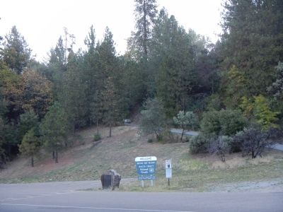
Location. 40° 45.266′ N, 122° 19.376′ W. Marker is in Shasta Lake, California, in Shasta County. Marker is on Bridge Bay Road, on the left when traveling north. Touch for map. Marker is at or near this postal address: 1300 Bridge Bay Road, Shasta Lake CA 96019, United States of America. Touch for directions.
Other nearby markers. At least 8 other markers are within 13 miles of this marker, measured as the crow flies. Stone Turnpike Memorial Freeway (approx. 2.7 miles away); Heroult Electric Arc Furnace (approx. 5.6 miles away); Klub Klondike (approx. 11 miles away); Veterans Memorial Grove (approx. 11.8 miles away); a different marker also named Stone Turnpike Memorial Freeway (approx. 11.9 miles away); Diestelhorst Auto Camp / Reid’s Ferry (approx. 12 miles away); Shasta Union High School War Memorial (approx. 12.3 miles away); Cascade Theater (approx. 12.4 miles away).
More about this marker. Bridge Bay Road is Interstate 5 Exit 690.
Regarding Pioneers Who “Held the Ribbons”. In 1935 this was designated California Historical Landmark No. 148 - Bass Hill. “On the summit of Bass Hill a remnant of the California-Oregon stage road crosses the Pacific Highway and descends to the Pit River. Because this was a favorite 'holdup' spot in stage-coach days, a marker has been placed there in memory of W. L. Smith, division stage agent of the California and Oregon Stage Company, and of the pioneer stage drivers along this road.”
Related marker. Click here for another marker that is related to this marker. This marker is a duplicate of a marker in Shasta, California except that it has the location Bass Hill added to the dedication information.
Credits. This page was last revised on January 23, 2024. It was originally submitted on October 28, 2013, by Barry Swackhamer of Brentwood, California. This page has been viewed 517 times since then and 29 times this year. Photos: 1, 2. submitted on October 28, 2013, by Barry Swackhamer of Brentwood, California. • Syd Whittle was the editor who published this page.

