
Washington in Beaufort County, North Carolina — The American South (South Atlantic)
Siege of Washington
March 30 - April 20, 1863
Photographed by Don Morfe, September 27, 2013
1. Siege of Washington Marker
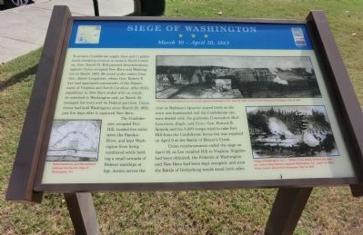
To protect Confederate supply lines and to gather much-need provisions in eastern North Carolina, Gen. Daniel H. Hill planned demonstrations against Union-occupied New Bern and Washington in March 1863. He acted under orders from Gen. James Longstreet, whom Gen. Robert E. Lee had appointed commander of the Department of Virginia and North Carolina. After Hill’s expedition to New Bern ended with no result, he marched to Washington and, on March 30, besieged the town and its Federal garrison. Union forces had held Washington since March 20, 1862, just five days after it captured New Bern.
The Confederates occupied Fort Hill, located five miles down the Pamlico River, and kept Washington from being reinforced with holding a small armada of Federal warships at bay. Action across the river at Rodman’s Quarter stayed lively as the town was bombarded and the Confederate cannons dueled with the gunboats Commodore Hull, Louisiana, Eagle, and Ceres. Gen. Francis B. Spinola and his 8,000 troops tried to take Fort Hill from the Confederate forces but was repulsed on April 9 at the Battle of Blount’s Creek.
Union reinforcements
this page online
(captions)
(lower left) Rebel batteries and the National defenses during the siege of Washington, N.C.
(upper right) “Shelling of rebel batteries in the woods opposite Washington, N.C. April 16, 1863.” Frank Leslie’s Illustrated Newspaper, May 16, 1863
(lower right) “Siege of Washington, N.C. — Effect of two shells, fired at the same, on a rebel cotton battery, opposite Washington , N.C. April 12, 1863.” Frank Leslie’s Illustrated Newspaper, May 16, 1863
Erected by North Carolina Civil War Trails.
Topics and series. This historical marker is listed in this topic list: War, US Civil. In addition, it is included in the North Carolina Civil War Trails series list. A significant historical month for this entry is March 1863.
Location. 35° 32.434′ N, 77° 3.254′ W. Marker is in Washington, North Carolina, in Beaufort County. It is at the intersection of East Water Street and South Bonner Street, on the right when traveling

Photographed by Devry Becker Jones (CC0), June 14, 2025
2. Siege of Washington Marker
Unfortunately, the marker has weathered significantly. Parts of the text, particularly the captions, are now illegible.

Regionally, this marker is in North Carolina’s Coastal Plain. It is also in the American South, specifically in the Upper South, in the Tidewater, and on the Eastern Seaboard. Globally, it is in the North Atlantic Region, North America, the Western Hemisphere, the Western World, and the Anglosphere. Historically, it finds itself in what was once the territory of the Mississippian Culture, one of the original Thirteen Colonies, one of the Confederate States of America, and the Antebellum South.
Other nearby markers. At least 8 other markers are within walking distance of this marker: Washington, North Carolina (within shouting distance of this marker); W.M. Chauncey (within shouting distance of this marker); The Purple Martin (within shouting distance of this marker); a different marker also named Washington (within shouting distance of this marker); Washington Storm Warning Tower (about 300 feet away,
Photographed by Don Morfe, September 27, 2013
3. Siege of Washington Marker
Credits. This page was last revised on June 22, 2025. It was originally submitted on November 30, 2013, by Don Morfe of Baltimore, Maryland. This page has been viewed 1,739 times since then and 60 times this year. Photos: 1. submitted on November 30, 2013, by Don Morfe of Baltimore, Maryland. 2. submitted on June 22, 2025, by Devry Becker Jones of Washington, District of Columbia. 3. submitted on November 30, 2013, by Don Morfe of Baltimore, Maryland. • Bernard Fisher was the editor who published this page.
