San Marcos in Hays County, Texas — The American South (West South Central)
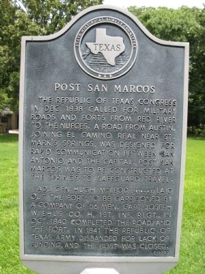
Post San Marcos
Adj. Gen. Hugh McLeod (1814-62) laid out the fort, to be garrisoned by a company of 56 men. Capt. Joseph Wiehl's Co. H, 1st Inf. Regt., in Oct. 1840 completed the road and the fort. In 1841 the Republic of Texas army disbanded for lack of funding, and the post was closed.
Erected 1973 by State Historical Survey Committee. (Marker Number 10311.)
Topics and series. This historical marker is listed in these topic lists: Forts and Castles • Hispanic Americans • Roads & Vehicles • War, Texas Independence. In addition, it is included in the El Camino Real de los Tejas National Historic Trail series list. A significant historical month for this entry is December 1838.
Location. 29° 53.576′ N, 97° 55.84′ W. Marker is in San Marcos, Texas, in Hays County. Marker can be reached from Aquarena Springs Drive south of West Laurel Street, on the right when traveling south. Behind the Visitor Center, Meadows Center Glass-bottom Boat Tours (formerly Aquarena Center). Touch for map. Marker is at or near this postal address: 951 Aquarena Springs Drive, San Marcos TX 78666, United States of America. Touch for directions.
Other nearby markers. At least 8 other markers are within walking distance of this marker. Texas Water Safari (about 500 feet away, measured in a direct line); San Marcos Springs (about 600 feet away); San Marcos Mill Tract (approx. 0.3 miles away); Spring Lake Dam (approx. 0.3 miles away); The Old Lime Kiln (approx. half a mile away); Riverhead Farm (approx. half a mile away); "Old Main" (approx. 0.6 miles away); In Commemoration of the Tonkawa and Chief Placido ("Ha-shu-ka-na") (approx. 0.6 miles away). Touch for a list and map of all markers in San Marcos.
Credits. This page was last revised on May 11, 2023. It was originally submitted on December 29, 2013, by Richard Denney of Austin, Texas. This page has been viewed 722 times since then and 39 times this year. Photo 1. submitted on December 29, 2013, by Richard Denney of Austin, Texas. • Bernard Fisher was the editor who published this page.
Editor’s want-list for this marker. Wide shot of marker and its surroundings. • Can you help?
