
Derry-Londonderry in Derry And Strabane, Northern Ireland, United Kingdom — Northwestern Europe (the British Isles)
Guildhall Square
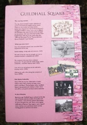
Photographed by William Fischer, Jr., September 18, 2012
1. Guildhall Square Marker
The roaring cannon
The city claims Europe's largest collection of cannon whose precise origins can be traced. These are the earliest surviving cannon. Some were shipped over for Sir Henry Docwra's campaign of 1600-3: others were sent to defend the Plantation city. Look for the marks stamped on the cannon - the rose and crown of the Tudor English kings, club and arrow marks, the date '1590' and the initials T.J. for Thomas Johnston, Queen Elizabeth I's gun founder.
'Wish you were here'
Over the centuries visitors have recorded their impressions of the city.
Stately buildings, strong walls and bulwarks. (1643)
The walls of the city, once its strength, are now its ornament and form a delightful mall. (1827)
The ramparts of the town form a pleasant promenade. The guns bear the names of the London Companies - venerable Cockney titles! (1843)
Look where you will and you will see the wall and a peeping cannon. (1930)
Walking the walls is like reliving four centuries of history. (2006)
Feis Doire Colmcille
Since 1924 the city has celebrated its Gaelic culture with a Feis, a festival of song, music, poetry and dance.
this page online
A city of horses
A century ago Guildhall Square echoed to the clip clop of hooves and the rumble of wooden and iron wheels. A line of horse-drawn cabs waited for fares alongside the wall. There were regular traffic jams of farmers' hay wagons, open-topped trams, donkey carts and horse-drawn lorries moving goods to and from the docks.
Topics. This historical marker is listed in these topic lists: Arts, Letters, Music • Forts and Castles • Man-Made Features • Settlements & Settlers. A significant historical year for this entry is 1924.
Location. 54° 59.839′ N, 7° 19.216′ W. Marker is in Derry-Londonderry, Northern Ireland, in Derry And Strabane. It can be reached from no nearby street. Marker is along the City Wall walking path along Guildhall Square, between Shipquay Gate and Magazine Gate. Touch for map. Marker is at or near this postal address: 13 Society Street, Derry-Londonderry, Northern Ireland BT48 6LU, United Kingdom. Touch for directions.

Regionally, this marker is in Northern Ireland’s
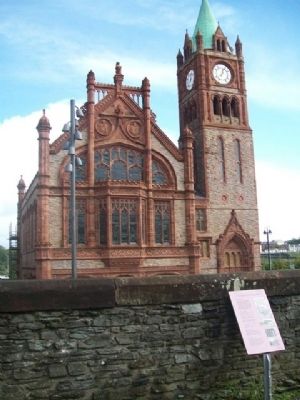
Photographed by William Fischer, Jr., September 18, 2012
2. Guildhall Square and Marker
Other nearby markers. At least 8 other markers are within walking distance of this marker: Michael Browning (here, next to this marker); Demi-culverin Cannon (a few steps from this marker); a different marker also named Demi-culverin Cannon (a few steps from this marker); Magazine Gate (a few steps from this marker); War Memorial (a few steps from this marker); The Walled City (within shouting distance of this marker); … Free, entire and perfect (within shouting distance of this marker); a different marker also named Guildhall Square (within shouting distance of this marker). Touch for a list and map of all markers in Derry-Londonderry.
Also see . . .
1. The Siege of Derry (1689). (Submitted on January 5, 2014, by William Fischer, Jr. of Reynoldsburg, Ohio.)
2. Ordnance at the end of the Elizabethan Age. (Submitted on January 5, 2014, by William Fischer, Jr. of Reynoldsburg, Ohio.)
Credits. This page was last revised on June 27, 2026. It was originally submitted on January 5, 2014, by William Fischer, Jr. of Reynoldsburg, Ohio. This page has been viewed 608 times since then and 10 times this year. Photos: 1, 2. submitted on January 5, 2014, by William Fischer, Jr. of Reynoldsburg, Ohio.
