Near Sharpsburg in Washington County, Maryland — The American Northeast (Mid-Atlantic)
Second Army Corps
Gorman's Brigade, Sedgwick's Division
Photographed by Craig Swain, March 29, 2008
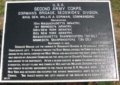
1. Gorman's Brigade Tablet
Second Army Corps,
Gorman's Brigade, Sedgwick's Division,
Brig. Gen. Willis A. Gorman, Commanding.
Organization.
15th Massachusetts Infantry,
1st Minnesota Infantry,
34th New York Infantry,
82d New York Infantry,
Massachusetts Sharpshooters (1st Co.)
Minnesota Sharpshooters (2d Co.)
September 17, 1862.
Gorman's Brigade led the advance of Sedgwick's Division in its assault upon the Confederate left. It passed through the East Woods, crossed the Cornfield and the open ground to the south, entered the West Woods and had reached this point, when its advance was checked by Jackson's command and the artillery of Stuart's Division posted on the high ground to the northwest. After a severe contest in which its ammunition was nearly exhausted, its left flank was turned by McLaws' and Walker's Divisions and the brigade was forced to retire northward to the fields beyond D.R. Miller's barn. The 34th New York was detached and occupied the woods immediately west of the Dunkard Church. This tablet marks the left center of the brigade in its advance.
Erected by Antietam Battlefield Board. (Marker Number 37.)
Topics and series. This
this page online
Location. 39° 28.695′ N, 77° 45.094′ W. Marker is near Sharpsburg, Maryland, in Washington County. It is on Hagerstown Pike (State Highway 65), on the right when traveling north. Located at stop 4 of the West Woods walking trail. Touch for map. Marker is in this post office area: Sharpsburg MD 21782, United States of America. Touch for directions.

Regionally, this marker is in Western Maryland. It is also in the American Mid-Atlantic, in Appalachia, and specifically in Northern Appalachia. Globally, it is in North America, the Western Hemisphere, the Western World, and the Anglosphere. Historically, it finds itself in what was once one of the original Thirteen Colonies.
Other nearby markers. At least 8 other markers are within walking distance of this marker: A different marker also named Second Army Corps (here, next to this marker); Ewell's Division, Jackson's Command (a few steps from this marker); a different marker also named
Photographed by Craig Swain, March 29, 2008
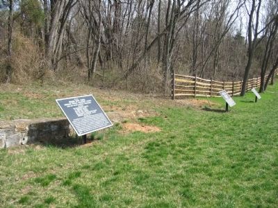
2. Federal Tablets in the West Woods
From left to right, Gorman's Brigade (Number 37), Dana's Brigade (Number 38), and Howard's Brigade (Number 39).
Also see . . .
1. Antietam Battlefield. National Park Service site. (Submitted on April 16, 2008, by Craig Swain of Leesburg, Virginia.)
2. 1st Brigade, 2nd Division, II Corps. In his official report Gorman would write, Although the firing was not so rapid, it was most deadly, and at very close range. We also had to stand the most terrific fire of grape and canister, which told fearfully on the three right regiments of the brigade....In this terrible conflict three regiments of the brigade, to wit, the Fifteenth Massachusetts, Thirty-fourth and Eighty-second New York Volunteers, lost nearly one-half their entire force engaged....The list of killed, wounded, and missing in action is herewith forwarded, showing the loss to be 758 out of 2,000 taken into the action.
Photographed by Craig Swain, March 29, 2008
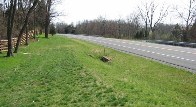
3. Gorman's Brigade Left Flank
The left flank of Gorman's Brigade was held by the 15th Massachusetts roughly at this point, along the modern Hagerstown Pike (looking south from near the tablet location). The 82nd New York held the center, where the modern road now passes. The 1st Minnesota held the right, on ground west of the modern road. The 34th New York, detached from the main portion of the Brigade, defended a position near the Dunker Church. Note the Stetson Memorial on the left in the distance.
Credits. This page was last revised on November 25, 2017. It was originally submitted on April 16, 2008, by Craig Swain of Leesburg, Virginia. This page has been viewed 1,062 times since then and 10 times this year. Photos: 1, 2, 3. submitted on April 16, 2008, by Craig Swain of Leesburg, Virginia.
