Imnaha in Wallowa County, Oregon — The American West (Northwest)
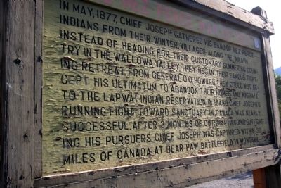
The Nez Perce War of 1877
Erected by United States Forest Service.
Topics and series. This historical marker is listed in these topic lists: Native Americans • Wars, US Indian. In addition, it is included in the The Nez Perce Trail series list. A significant historical month for this entry is May 1877.
Location. 45° 33.559′ N, 116° 49.994′ W. Marker is in Imnaha, Oregon, in Wallowa County. Marker is on Hat Point Road east of Upper Imnaha Road, on the right when traveling east. Marker is located next to parking lot behind the post office. Touch for map. Marker is at or near this postal address: 201 Hat Point Road, Imnaha OR 97842, United States of America. Touch for directions.
Other nearby markers. At least 3 other markers are within 8 miles of this marker, measured as the crow flies. Horse Creek Overlook (approx. 7 miles away); A Monumental Landscape (approx. 7 miles away); The Imnaha Canyon ... shelter and sanctuary (approx. 7.9 miles away).
Also see . . . Nez Perce War - Wikipedia entry. (Submitted on February 14, 2014.)
Credits. This page was last revised on June 16, 2016. It was originally submitted on February 14, 2014, by Duane Hall of Abilene, Texas. This page has been viewed 689 times since then and 83 times this year. Photo 1. submitted on February 14, 2014, by Duane Hall of Abilene, Texas.
Editor’s want-list for this marker. Better photo of marker. Photo of wide-view of marker and surroundings. • Can you help?
