Kawaihae in Hawaii County, Hawaii — Hawaiian Island Archipelago (Pacific Ocean)
Pu'ukohola Heiau
A Sacred Place Since Prehistoric Times
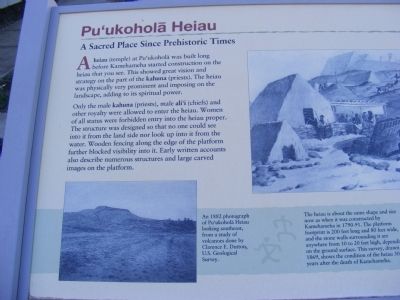
Only the male kahuna (priests), male ali’i (chiefs) and other royalty were allowed to enter the heiau. Women of all status were forbidden entry into the heiau proper. The structure was designed so that no one could see into it from the land side nor look up into it from the water. Wooden fencing along the edge of the platform further blocked visibility into it. Early written accounts also describe numerous structures and large carved images on the platform.
(Inscription next to the photo in the lower left) An 1882 photograph of Pu’ukohola Heiau looking southeast, from a study of volcanoes done by Clarence E. Dutton, U.S. Geological Survey.
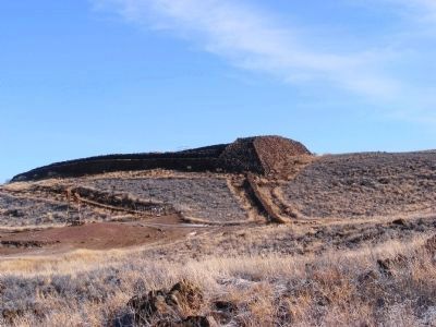
(Inscription below the photo in the upper right) The heiau is about the same shape and size now as when it was constructed by Kamehamela in 1790-91. The platform footprint is 200 feet long and 80 feet wide, and the stone walls surrounding it are anywhere from 10 to 20 feet high depending on the ground surface. This survey, drawn in 1869, shows the condition of the heiau 50 years after the death of Kamehameha.
Erected by National Park Service-United States Department of the Interior.
Topics. This historical marker is listed in these topic lists: Anthropology & Archaeology • Churches & Religion. A significant historical year for this entry is 1882.
Location. 20° 1.662′ N, 155° 49.368′ W. Marker is in Kawaihae, Hawaii, in Hawaii County. Marker is on Kawaihae Road (SR270). The marker is on the grounds of the National Historic Site. Touch for map. Marker is in this post office area: Kamuela HI 96743, United States of America. Touch for directions.
Other nearby markers. At least 8 other markers are within 6 miles of this marker, measured as the crow flies. Hale o Kapuni Heiau (here, next to this marker); Mailekini Heiau (within shouting distance of this marker); Pelekane (within shouting distance of this marker); Pu'ukohlā Heiau (about 300 feet away, measured in a direct line); Pu'ukoholā Heiau (about 400 feet away); Pu'ukohola Heiau National Historic Site (approx. 0.2 miles away); Camp Henry C. Drewes (approx. 2˝ miles away); Puakō Petroglyph Archaeological District (approx. 5˝ miles away).
Credits. This page was last revised on June 16, 2016. It was originally submitted on February 20, 2014, by Don Morfe of Baltimore, Maryland. This page has been viewed 497 times since then and 14 times this year. Photos: 1, 2, 3, 4. submitted on February 20, 2014, by Don Morfe of Baltimore, Maryland. • Bill Pfingsten was the editor who published this page.


