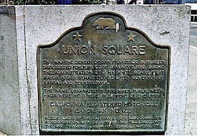
Union Square in San Francisco City and County, California — The American West (Pacific Coastal)
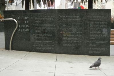
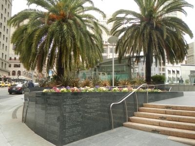
History of Union Square
1839 Jean Vioget laid out the first plan of Yerba Buena (later San Francisco), showing the Union Square site as a future park.
1847 Jasper O’Farrell created a second, more accurate plan for the blocks of San Francisco, designating this site as a public square. The site was a sand dune called O’Farrell’s Mountain.
1850 Colonel John Geary deeded the block to the City to be held in perpetuity for park use.
1860 (circa) The sand dune was removed and the first design for a public square was completed.
1861-1865 The block was named ‘Union Square’ to commemorate public rallies held here in support of the Union during the Civil War.
1871-1880 The site was cleared and redesigned as a formal strolling garden. Churches and residences surrounded the square.
1877 Cable cars were operating on Powell Street.
1878 Cable cars began running on Geary Street.
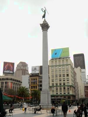
1900-1903 Union Square was redesigned with the Dewey Memorial at its center. The memorial was designed by sculptor Robert J. Aitkin and architect Newton J. Tharpe. The ‘Winged Victory’ bronze figure was modeled after Alma Spreckels, San Francisco socialite, and was named after U.S. Navaal Admiral George Dewey.
1903 The Dewey Memorial was dedicated by President Theodore Roosevelt on May 14.
1905 (circa) By the turn of the century offices, businesses, theaters and hotel surrounded Union Square. The first hotel was the St. Frances located on Powell Street.
1906 The Great Earthquake and Fire destroyed all buildings around Union Square. Temporary hotel rooms were built on the Square while the St. Francis was rebuilt and expanded.
1923 The Fitzhugh Building was built at the corner of Post and Powell Streets where the Saks Fifth Avenue Building stands today.
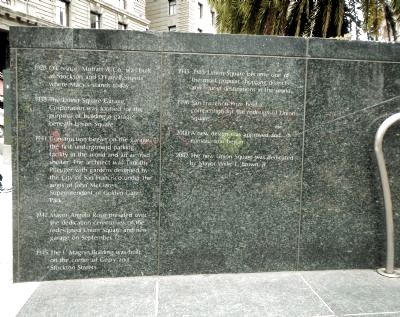
1928 O’Connor, Moffat & Co. was built at Stockton and O’Farrell Streets where Macy’s stands today.
1938 The Union Square Garage Corporation was formed for the purpose of building a garage beneath Union Square.
1941 Construction began on the garage, the first underground parking facility in the world and an air-raid shelter. The architect was Timothy Pfleuger with gardens designed by the City of San Francisco under the aegis of John McClaren, Superintendent of Golden Gate Park.
1942 Mayor Angelo Rossi presided over the dedication ceremonies of the redesigned Union Square and new garage on September 12.
1945 The I. Magnin Building was built on the corner of Geary and Stockton Streets.
1945-1985 Union Square became one of the most popular shopping districts and tourist destinations in the world.
1996 San Francisco Prize held a competition for the redesign of Union Square.
2000 A new design was approved and construction began.
2002 The new Union Square was dedicated by Mayor Willie L. Brown, Jr. (Marker Number 623.)
Topics and series. This historical marker is listed in these topic lists: Charity & Public Work • Parks & Recreational Areas • Railroads & Streetcars • Settlements & Settlers. In addition, it is included in the California Historical Landmarks, and the Former U.S. Presidents: #26 Theodore Roosevelt series lists. A significant historical month for this entry is May 1756.
Location. 37° 47.274′ N, 122° 24.488′ W. Marker is in San Francisco, California, in San Francisco City and County. It is in Union Square. Marker is on Powell Street, on the right when traveling north. Touch for map. Marker is at or near this postal address: 350 Powell Street, San Francisco CA 94108, United States of America. Touch for directions.
Other nearby markers. At least 8 other markers are within walking distance of this marker. Dewey Monument (within shouting distance of this marker); Sears Fine Food (about 400 feet away, measured in a direct line); Mayors of San Francisco (about 400 feet away); “The D’Arcy Building” (about 500 feet away); Native Sons Building (about 500 feet away); Marines Memorial Club (about 800 feet away); Miles Archer (approx. 0.2 miles away); John's Grill (approx. 0.2 miles away). Touch for a list and map of all markers in San Francisco.
Regarding History of Union Square. In 1957, Union Square was designated California Historical Landmark No. 623 - “This was the center of San Francisco in pioneer days, deeded for public use January 3, 1850 during the administration of John White Geary, first mayor and postmaster, and later Governor of Kansas and Pennsylvania. The name originated in 1860 when public meetings were held here in support of the Union.”
Also see . . . A History of Union Square - found SF. Today San Francisco's Union Square forms one of the most notable outdoor spaces in the world, functioning as a major "urban room" in the heart of downtown San Francisco. The history of the Square goes back to the city's very beginnings. Early maps of San Francisco based on surveys by Jean Vioget (1839) and Jasper O'Farrell (1847) show Washington Square and Union Square, both then unnamed, reserved as public squares. (Submitted on February 22, 2014, by Barry Swackhamer of Brentwood, California.)
Additional keywords. California Historical Landmark, Urban Public Park
Credits. This page was last revised on February 5, 2024. It was originally submitted on February 22, 2014, by Barry Swackhamer of Brentwood, California. This page has been viewed 1,022 times since then and 144 times this year. Photos: 1, 2, 3, 4. submitted on February 22, 2014, by Barry Swackhamer of Brentwood, California. 5. submitted on February 5, 2024. • Bill Pfingsten was the editor who published this page.
